Altenahr
Municipality in Rhineland-Palatinate, Germany

Coat of arms
Location of Altenahr within Ahrweiler district

(2022-12-31)[2]
53502–53505
Altenahr (German pronunciation: [altn̩ˈʔaːɐ̯]) is a municipality in the district of Ahrweiler, in Rhineland-Palatinate, Germany. It is the administrative centre for the eponymous collective municipality, to which it belongs. Altenahr is a state-recognised tourist resort and is ranked as a Grundzentrum for state planning purposes.[3]
Geography
Location
Altenahr is situated on the river Ahr, on the northeastern edge of the Ahr Hills. part of the Eifel mountains, approximately 10 kilometres west of Bad Neuenahr-Ahrweiler and about 35 kilometres southwest of Bonn.
Administrative organisation
The municipality of Altenahr comprises the following parishes: Altenahr, Altenburg, Kreuzberg and Reimerzhoven.
Neighbouring municipalities
Altenahr borders on the following neighbouring municipalities, listed clockwise from the north: Kalenborn, Grafschaft, Mayschoß, Ahrbrück, Lind and Berg.
Climate
The annual precipitation is 668 mm which is in the middle third of readings collected for Germany as a whole. 34% of weather stations of the German Meteorological Service record lower values. The driest month is February, the greatest amount of rain falls in July; 1.6 times that of February. However, in general the level of precipitation varies little and is evenly distributed over the year. Only 13% of weather stations record lower seasonal variations.
The town was almost entirely submerged during the 2021 European floods.[4]
History
Altenahr was first mentioned in 893 in the Prüm Urbar.
Incorporations
On 7 June 1969 the hitherto independent municipality of Kreuzberg, with its 560 inhabitants, was incorporated into Altenahr.[5]
Population growth
The growth in Altenahr's population related to the present-day municipal area; the values from 1871 to 1987 are based on censuses:[3][6]
|
|
Gallery
-
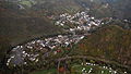 Altenahr, aerial photograph, 2015
 -
 Photograph of Altenahr in about 1900


References
- ^ Direktwahlen 2019, Landkreis Ahrweiler, Landeswahlleiter Rheinland-Pfalz, accessed 3 August 2021.
- ^ "Bevölkerungsstand 2022, Kreise, Gemeinden, Verbandsgemeinden" (PDF) (in German). Statistisches Landesamt Rheinland-Pfalz. 2023.
- ^ a b Statistisches Landesamt Rheinland-Pfalz - Regional data
- ^ Flooding in Germany: Before and after images from the Ahr and Eifel regions. Deutsche Welle. 17 Jul 2021.
- ^ Statistisches Landesamt Rheinland-Pfalz – Amtliches Gemeindeverzeichnis 2006 Archived 2011-07-18 at the Wayback Machine, pages 168, 177 (pdf; 2.1 MB)
- ^ Statistisches Bundesamt – number of inhabitants in the municipalities on 31 December 2016.
- v
- t
- e
Towns and municipalities in Ahrweiler
- Adenau
- Ahrbrück
- Altenahr
- Antweiler
- Aremberg
- Bad Breisig
- Bad Neuenahr-Ahrweiler
- Barweiler
- Bauler
- Berg
- Brenk
- Brohl-Lützing
- Burgbrohl
- Dankerath
- Dedenbach
- Dernau
- Dorsel
- Dümpelfeld
- Eichenbach
- Fuchshofen
- Galenberg
- Glees
- Gönnersdorf
- Grafschaft
- Harscheid
- Heckenbach
- Herschbroich
- Hoffeld
- Hohenleimbach
- Honerath
- Hönningen
- Hümmel
- Insul
- Kalenborn
- Kaltenborn
- Kempenich
- Kesseling
- Kirchsahr
- Königsfeld
- Kottenborn
- Leimbach
- Lind
- Mayschoß
- Meuspath
- Müllenbach
- Müsch
- Niederdürenbach
- Niederzissen
- Nürburg
- Oberdürenbach
- Oberzissen
- Ohlenhard
- Pomster
- Quiddelbach
- Rech
- Reifferscheid
- Remagen
- Rodder
- Schalkenbach
- Schuld
- Senscheid
- Sierscheid
- Sinzig
- Spessart
- Trierscheid
- Waldorf
- Wassenach
- Wehr
- Weibern
- Wershofen
- Wiesemscheid
- Wimbach
- Winnerath
- Wirft

Authority control databases | |
|---|---|
| International |
|
| National |
|
 | This Ahrweiler location article is a stub. You can help Wikipedia by expanding it. |
- v
- t
- e


