Beaches of Aruba
Map all coordinates using OpenStreetMap
Download coordinates as:
- KML
- GPX (all coordinates)
- GPX (primary coordinates)
- GPX (secondary coordinates)

There are more than a dozen beaches of Aruba. Aruba is part of the Kingdom of the Netherlands and an island country in the mid-south of the Caribbean Sea.
Beaches
The beaches of Aruba include the following:
- Andicuri Beach, 12°32′25″N 69°57′15″W / 12.54017°N 69.95405°W / 12.54017; -69.95405 (Andicuri Bay)[1]
- Arashi Beach, 12°36′34″N 70°03′14″W / 12.60955°N 70.05398°W / 12.60955; -70.05398 (Arashi Cove Beach)[2][1]
- Baby Beach, 12°24′53″N 69°52′51″W / 12.414691561947045°N 69.88080110113886°W / 12.414691561947045; -69.88080110113886 (Baby Beach)[1][3]
- Bachelor's Beach, 12°25′55″N 69°52′19″W / 12.432048879438073°N 69.87190087340504°W / 12.432048879438073; -69.87190087340504 (Bachelor's Beach)[3]
- Beach at the Blue Residences, 12°33′42″N 70°03′17″W / 12.561552177770563°N 70.05461831601973°W / 12.561552177770563; -70.05461831601973 (Beach at the Blue Residences)[3]
- Boca Catalina Beach, 12°36′17″N 70°03′06″W / 12.604599275220952°N 70.05154788992112°W / 12.604599275220952; -70.05154788992112 (Boca Catalina Beach)[1][3]
- Boca Grandi Beach, 12°26′25″N 69°52′26″W / 12.440179110955492°N 69.87391789463777°W / 12.440179110955492; -69.87391789463777 (Boca Grandi Beach)[3]
- Boca Prins Beach, Arikok National Park, 12°29′57″N 69°54′25″W / 12.499268155134015°N 69.90690549769073°W / 12.499268155134015; -69.90690549769073 (Boca Prins)[1][3]
- Cura Cabay Beach, 12°26′25″N 69°55′49″W / 12.440230544063645°N 69.93035316884772°W / 12.440230544063645; -69.93035316884772 (Cura Cabay Beach)
- Daimari Beach, 12°31′52″N 69°56′25″W / 12.53097730179607°N 69.9402757457267°W / 12.53097730179607; -69.9402757457267 (Daimari Beach)[3]
- Divi Beach, 12°32′15″N 70°03′34″W / 12.537543549026955°N 70.05944983277939°W / 12.537543549026955; -70.05944983277939 (Divi Beach)[3]
- Dos Playa Beach, Arikok National Park, 12°30′21″N 69°55′08″W / 12.505709317860248°N 69.91879125150759°W / 12.505709317860248; -69.91879125150759 (Dos Playa Beach)[1]
- Druif Beach, 12°36′20″N 70°01′54″W / 12.60569°N 70.0318°W / 12.60569; -70.0318 (Druif Beach)[1][4]
- Eagle Beach, 12°32′52″N 70°03′25″W / 12.54786°N 70.0569°W / 12.54786; -70.0569 (Eagle Beach)[5][1]
- Flamingo Beach, Renaissance Island, 12°30′05″N 70°01′46″W / 12.50127°N 70.02953°W / 12.50127; -70.02953 (Flamingo Beach)[6]
- Grapefield Beach, 12°26′55″N 69°52′37″W / 12.448602432969578°N 69.8770077994854°W / 12.448602432969578; -69.8770077994854 (Grapefield Beach)
- Hadicurari Beach, 12°35′09″N 70°02′46″W / 12.585830474743323°N 70.04606410264978°W / 12.585830474743323; -70.04606410264978 (Handicurari Beach)[1][3]
- Iguana Beach, 12°30′01″N 70°01′42″W / 12.50036°N 70.02834°W / 12.50036; -70.02834 (Iguana Beach)[7]
- Malmok Beach, 12°35′53″N 70°02′59″W / 12.598006661360682°N 70.04978184187625°W / 12.598006661360682; -70.04978184187625 (Malmo Beach)[1][3]
- Manchebo Beach, 12°32′25″N 70°03′48″W / 12.54024°N 70.06342°W / 12.54024; -70.06342 (Manchebo Beach)[8]
- Mangel Halto Beach, 12°27′54″N 69°58′10″W / 12.464923508766375°N 69.96952414935305°W / 12.464923508766375; -69.96952414935305 (Mangel Halto Beach)[3]
- Palm Beach, 12°34′31″N 70°02′45″W / 12.575175775385796°N 70.04573530313544°W / 12.575175775385796; -70.04573530313544 (Palm Beach)[9][1][3]
- De Palm Island, 12°28′20″N 69°59′10″W / 12.472150386817194°N 69.98618229648267°W / 12.472150386817194; -69.98618229648267 (Palm Island)[1][3]
- Rincon Beach, 12°27′17″N 69°52′47″W / 12.454731170852979°N 69.87963636429994°W / 12.454731170852979; -69.87963636429994 (Rincon Beach)[3]
- Rodgers Beach, 12°25′02″N 69°53′03″W / 12.41719°N 69.88413°W / 12.41719; -69.88413 (Rodgers Beach)[10][1]
- Surfside Beach, 12°30′23″N 70°01′49″W / 12.5063215093638°N 70.03022095363487°W / 12.5063215093638; -70.03022095363487 (Surfside Beach)[1][3]
- Wariruri Beach, 12°33′33″N 69°59′17″W / 12.559253559320023°N 69.98819072756311°W / 12.559253559320023; -69.98819072756311 (Wariruri Beach)[3]
Gallery
Beach scenes in Aruba
-
 Andicuri beach from natural bridge
 -
 Arashi Beach
 -
 Baby Beach
 -
 Eagle Beach
 -
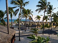 Manchebo Beach
 -
 Mangel Halto Beach
 -
 Palm Beach
 -
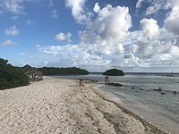
 Rodgers Beach


See also
Wikimedia Commons has media related to Aruba.
Wikivoyage has a travel guide for Aruba.
- Geography of Aruba
- Islands of Aruba
- Caves of Aruba
References
- ^ a b c d e f g h i j k l m n "Aruba's Beaches and Coves". Aruba.com. Retrieved September 21, 2021.
- ^ "Arashi Cove". GeoNames. Retrieved September 21, 2021.
- ^ a b c d e f g h i j k l m n o p Google Maps
- ^ "Druif Beach". GeoNames. Retrieved September 21, 2021.
- ^ "Eagle Beach". GeoNames. Retrieved September 21, 2021.
- ^ "Flamingo Beach". GeoNames. Retrieved September 21, 2021.
- ^ "Iguana Beach". GeoNames. Retrieved September 21, 2021.
- ^ "Manchebo Beach". GeoNames. Retrieved September 21, 2021.
- ^ "Palm Beach". GeoNames. Retrieved September 21, 2021.
- ^ "Rodgers Beach". GeoNames. Retrieved September 21, 2021.
- v
- t
- e
Beaches of the Caribbean
- British West Indies
- Danish West Indies
- Dutch Caribbean
- Caribbean Netherlands
- Netherlands Antilles
- French West Indies
- West Indies Federation
Indies
| Antilles |
| ||||||||||||||||||||
|---|---|---|---|---|---|---|---|---|---|---|---|---|---|---|---|---|---|---|---|---|---|
| Lucayan Archipelago |
Sea
- Aves Island
- San Andrés and Providencia
- Bajo Nuevo Bank~
- Serranilla Bank~
continental
zone
- Quintana Roo
- Cozumel
| Central America |
|
|---|---|
| South America |
|
groupings
may include:
- Bermuda#
- Costa Rica
- El Salvador
- Guatemala
- Nicaragua
| Yucatán Peninsula |
|
|---|---|
| The Guianas |
|
N.B.: Territories in italics are parts of transregional sovereign states or non-sovereign dependencies.
^These three form the SSS islands that with the ABC islands comprise the Dutch Caribbean, of which *the BES islands are not direct Kingdom constituents but subsumed with the country of the Netherlands.
†Physiographically, these continental islands are not part of the volcanic Windward Islands arc, although sometimes grouped with them culturally and politically.
ǂDisputed territories administered by Guyana. ~Disputed territories administered by Colombia.
#Bermuda is an isolated North Atlantic oceanic island, physiographically not part of the Lucayan Archipelago, Antilles, Caribbean Sea nor North American continental nor South American continental islands. It is grouped with the Northern American region, but occasionally also with the Caribbean region culturally.


