Cuxhaven (district)
District in Lower Saxony, Germany
District in Lower Saxony, Germany

Flag

Coat of arms

(31 December 2022)[1]
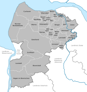
Cuxhaven is a district (Landkreis) in Lower Saxony, Germany. It is bounded by (from the east and clockwise) the districts of Stade, Rotenburg, Osterholz and Wesermarsch, the city of Bremerhaven and the North Sea.
History
The district was established in 1977 by merging the former districts of Land Hadeln and Wesermünde. The town of Cuxhaven lost its status as a district-free town and became the capital of the new district.
Geography
The district is often nicknamed Cuxland. It is located on the coast of the North Sea and is enclosed by the river mouths of Elbe and Weser. The coasts are part of the Lower Saxony Wadden Sea National Park.
Coat of arms
The arms display Saint Nicholas, who is the patron saint of fishermen. The coast of the North Sea is symbolised at the bottom of the arms.
Towns and municipalities
| Towns | Samtgemeinden | ||
|---|---|---|---|
|
| 2. Hemmoor
| 3. Land Hadeln
| |
| 1seat of the Samtgemeinde; 2town | |||
References
- ^ "LSN-Online Regionaldatenbank, Tabelle A100001G: Fortschreibung des Bevölkerungsstandes, Stand 31. Dezember 2022" (in German). Landesamt für Statistik Niedersachsen.
External links
Wikimedia Commons has media related to Landkreis Cuxhaven.
- Official website (in German)
- Cuxland tourist website (in German)
- v
- t
- e
 Urban and rural districts in the state of Lower Saxony in Germany
- Ammerland
- Aurich
- Bentheim
- Celle
- Cloppenburg
- Cuxhaven
- Diepholz
- Emsland
- Friesland
- Gifhorn
- Goslar
- Göttingen
- Hameln-Pyrmont
- Harburg
- Heidekreis
- Helmstedt
- Hildesheim
- Holzminden
- Leer
- Lüchow-Dannenberg
- Lüneburg
- Nienburg
- Northeim
- Oldenburg
- Osnabrück
- Osterholz
- Peine
- Rotenburg
- Schaumburg
- Stade
- Uelzen
- Vechta
- Verden
- Wesermarsch
- Wittmund
- Wolfenbüttel
Districts of German states (Full list)
- Baden-Württemberg
- Bavaria
- Brandenburg
- Bremen
- Hesse
- Lower Saxony
- Mecklenburg-Vorpommern
- North Rhine-Westphalia
- Rhineland-Palatinate
- Saarland
- Saxony
- Saxony-Anhalt
- Schleswig-Holstein
- Thuringia
53°40′N 8°50′E / 53.67°N 8.83°E / 53.67; 8.83
Authority control databases | |
|---|---|
| International |
|
| National |
|


