Freudenstadt (district)
You can help expand this article with text translated from the corresponding article in German. (June 2020) Click [show] for important translation instructions.
- Machine translation, like DeepL or Google Translate, is a useful starting point for translations, but translators must revise errors as necessary and confirm that the translation is accurate, rather than simply copy-pasting machine-translated text into the English Wikipedia.
- Do not translate text that appears unreliable or low-quality. If possible, verify the text with references provided in the foreign-language article.
- You must provide copyright attribution in the edit summary accompanying your translation by providing an interlanguage link to the source of your translation. A model attribution edit summary is
Content in this edit is translated from the existing German Wikipedia article at [[:de:Landkreis Freudenstadt]]; see its history for attribution. - You may also add the template
{{Translated|de|Landkreis Freudenstadt}}to the talk page. - For more guidance, see Wikipedia:Translation.
District in Baden-Württemberg, Germany

Flag

Coat of arms

(31 December 2022)[1]
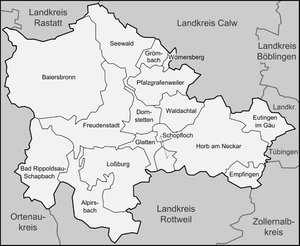
Freudenstadt is a Landkreis (district) in the middle of Baden-Württemberg, Germany. Neighboring districts are (from north clockwise) Rastatt, Calw, Tübingen, Zollernalbkreis, Rottweil and the Ortenaukreis.
History
The district was created in 1938 as the successor of the Oberamt Freudenstadt which dated back to 1806. In 1973 it was merged with the majority of the neighboring district of Horb, and some small parts of the districts of Wolfach and Hechingen.
Geography
The district is located in the middle part of the Black Forest mountains. The river Neckar flows through the southeast of the district.
Coat of arms
 | The coat of arms displays a capercaillie, which once was quite common in the area. The colors yellow and black are chosen as they are the colors of Württemberg. |
Towns and municipalities
| Cities | Towns |
|---|---|
| Administrative districts | |
|
References
- ^ "Bevölkerung nach Nationalität und Geschlecht am 31. Dezember 2022" [Population by nationality and sex as of December 31, 2022] (CSV) (in German). Statistisches Landesamt Baden-Württemberg. June 2023.
External links
Wikimedia Commons has media related to Landkreis Freudenstadt.
- Official website (German, English, French)
- v
- t
- e


- Freiburg
- Karlsruhe
- Stuttgart
- Tübingen
- Alb-Donau
- Biberach
- Bodensee
- Böblingen
- Breisgau-Hochschwarzwald
- Calw
- Emmendingen
- Enz
- Esslingen
- Freudenstadt
- Göppingen
- Heidenheim
- Heilbronn
- Hohenlohe
- Karlsruhe
- Konstanz
- Lörrach
- Ludwigsburg
- Main-Tauber
- Neckar-Odenwald
- Ortenau
- Ostalbkreis
- Rastatt
- Ravensburg
- Rems-Murr
- Reutlingen
- Rhein-Neckar
- Rottweil
- Schwäbisch Hall
- Schwarzwald-Baar
- Sigmaringen
- Tübingen
- Tuttlingen
- Waldshut
- Zollernalb
Towns and municipalities in Freudenstadt (district) | ||
|---|---|---|
 | ||
Authority control databases | |
|---|---|
| International |
|
| National |
|
48°30′N 8°25′E / 48.5°N 8.42°E / 48.5; 8.42


