Halfway, County Cork
Village in County Cork, Ireland
Village in Munster, Ireland
Halfway Irish: Leath Slighe | |
|---|---|
Village | |
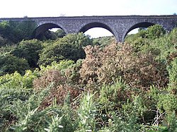 The Halfway Viaduct, on the former Cork, Bandon and South Coast Railway, sits above the village | |
| 51°48′07″N 8°34′25″W / 51.801967°N 8.573542°W / 51.801967; -8.573542 | |
| Country | Ireland |
| Province | Munster |
| County | Cork |
| Population (2016)[1] | 226 |
| Time zone | UTC+0 (WET) |
| • Summer (DST) | UTC-1 (IST (WEST)) |
| Irish Grid Reference | W605615 |
Halfway (Irish: Leath Slighe) is a village in County Cork, in Ireland. Halfway got its name from being situated approximately halfway between Cork City and Bandon.
Halfway is situated on the L2231, just off the N71, close to the neighbouring village of Ballinhassig. Ballinhassig Garda station is located in Halfway.[2] Halfway formerly had two pubs; however, there is now only the Ramble Inn pub.[citation needed] There is also an angling shop.[3]
The annual Halfway Vintage Rally, a meeting of vintage car owners and enthusiasts, takes place over one weekend in September.[citation needed] Road bowling is sometimes played on the national road between the villages of Halfway and Ballinhassig.[4]
Evidence of ancient settlement in the area includes several ringforts in the neighbouring townlands of Gortnaclogh, Annagh Beg and Rathroe.[5]
See also
References
- ^ "Sapmap Area - Settlements - Halfway". Census 2016. Central Statistics Office. April 2016. Archived from the original on 13 February 2018. Retrieved 4 November 2020.
- ^ "Ballinhassig Garda Station, Halfway, Ballinhassig, Co. Cork". garda.ie. An Garda Síochána. Archived from the original on 31 March 2021. Retrieved 23 December 2020.
- ^ "Tackle Direct Ireland - Contact Us". tackledirectireland.ie. Halfway Angling Centre. Archived from the original on 26 January 2021. Retrieved 23 December 2020.
- ^ "Club Results". irishroadbowling.ie. Archived from the original on 6 February 2008. Retrieved 5 March 2008.
- ^ "Recorded Monuments Protected under Section 12 of the National Monuments (Amendment) Act, 1994 County Cork" (PDF). archaeology.ie. National Monuments and Historic Properties Service. 1998. Archived (PDF) from the original on 1 September 2021. Retrieved 4 November 2020.

- v
- t
- e
Places in County Cork
County town: Cork

Townlands
- Adrigole
- Aghabullogue
- Aghada
- Ahakista
- Aherla
- Ahiohill
- Allihies
- Ardfield
- Ardgroom
- Ballinacurra
- Ballinadee
- Ballinagree
- Ballinascarty
- Ballineen
- Ballingeary
- Ballinhassig
- Ballinora
- Ballinspittle
- Ballintemple
- Ballycotton
- Ballydehob
- Ballydesmond
- Ballygarvan
- Ballylickey
- Ballymakeera
- Ballymore
- Ballyvourney
- Baltimore
- Banteer
- Béal na Bláth
- Belgooly
- Belvelly
- Blarney
- Boherbue
- Bridebridge
- Bweeng
- Canovee
- Carrigadrohid
- Carriganimmy
- Carrigtwohill
- Castlehaven
- Castlelyons
- Castlemagner
- Castlemartyr
- Castletown-Kinneigh
- Castletownbere
- Castletownroche
- Castletownshend
- Churchtown
- Cloghroe
- Clondulane
- Cloughduv
- Cloyne
- Coachford
- Conna
- Coolea
- Courtmacsherry
- Crookhaven
- Crookstown
- Crossbarry
- Crosshaven
- Cullen
- Doneraile
- Douglas
- Drimoleague
- Dripsey
- Dromahane
- Dungourney
- Dunmanway
- Durrus
- Enniskean
- Eyeries
- Farran
- Fermoy
- Fountainstown
- Freemount
- Glandore
- Glanmire
- Glantane
- Glanworth
- Glasheen
- Glenbrook
- Glengarriff
- Glenville
- Glounthaune
- Goleen
- Gougane Barra
- Halfway
- Innishannon
- Kilbrin
- Kilbrittain
- Kilmichael
- Kilnamartyra
- Killumney
- Kilworth
- Kiskeam
- Knockavilla
- Knocknagree
- Knockraha
- Ladysbridge
- Leap
- Liscarroll
- Lisgoold
- Lismire
- Lombardstown
- Lyre
- Mayfield
- Meelin
- Milford
- Minane Bridge
- Mitchelstown
- Monard
- Monkstown
- Montenotte
- Mourneabbey
- Nad
- Newcestown
- Newmarket
- Newtwopothouse
- Nohoval
- Ovens
- Rathbarry
- Rathcormac
- Riverstick
- Roberts Cove
- Rockchapel
- Rosscarbery
- Rylane
- Sallybrook
- Schull
- Shanagarry
- Shanbally
- Shanballymore
- Timoleague
- Togher
- Tower
- Union Hall
- Upton
- Waterfall
- Watergrasshill
- Whitegate
- Mountains
- Ballyhoura Mountains
- Boggeragh Mountains
- Caha Mountains
- Derrynasaggart Mountains
- Galtee Mountains
- Mullaghareirk Mountains
- Shehy Mountains
- Slieve Miskish Mountains
- Rivers
- River Bandon
- River Blackwater
- River Lee
- Heads
- Brow Head
- Mizen Head
- Sheep's Head
- Islands
- Ballycotton Island
- Bere Island
- Cape Clear Island
- Capel Island
- Carbery's Hundred Isles
- Fastnet Rock
- Dursey Island
- Garinish
- Great Island
- Heir Island
- Haulbowline Island
- Inishfarnard
- Long Island
- Sherkin Island
- Spike Island
- Whiddy Island
- Lists of townlands of County Cork
- Mountains and hills of County Cork
- Rivers of County Cork
- Geography of County Cork
 | This geographical article about County Cork is a stub. You can help Wikipedia by expanding it. |
- v
- t
- e


