Hohentengen am Hochrhein
You can help expand this article with text translated from the corresponding article in German. (February 2009) Click [show] for important translation instructions.
- View a machine-translated version of the German article.
- Machine translation, like DeepL or Google Translate, is a useful starting point for translations, but translators must revise errors as necessary and confirm that the translation is accurate, rather than simply copy-pasting machine-translated text into the English Wikipedia.
- Do not translate text that appears unreliable or low-quality. If possible, verify the text with references provided in the foreign-language article.
- You must provide copyright attribution in the edit summary accompanying your translation by providing an interlanguage link to the source of your translation. A model attribution edit summary is
Content in this edit is translated from the existing German Wikipedia article at [[:de:Hohentengen am Hochrhein]]; see its history for attribution. - You may also add the template
{{Translated|de|Hohentengen am Hochrhein}}to the talk page. - For more guidance, see Wikipedia:Translation.
Municipality in Baden-Württemberg, Germany

Coat of arms
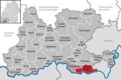
Location of Hohentengen am Hochrhein within Waldshut district
(2023–31) Jürgen Wiener[1]
(2022-12-31)[2]
79801
Hohentengen is a municipality in the district of Waldshut in Baden-Württemberg in Germany.
Geography
Location
The village Hohentengen lies on the northern banks of the Rhine, overlooking Switzerland. The right weather conditions allow a view of the Swiss Alpes from the 'Kalten Wangen', a mountain in the district of Stetten. Hohentengen am Hochrhein comprises six districts: Hohentengen, Lienheim, Herdern, Bergöschingen, Günzgen and Stetten.
Neighbouring towns
Hohentengen borders to Klettgau in the north, the Swiss towns of Wasterkingen and Hüntwangen in the east, Glattfelden and Weiach in the south, which are all part of the Kanton Zürich, as well as Kaiserstuhl, Aargau, Fisibach, and Rümikon, which are part of the Kanton Aargau. In the west, Hohentengen borders to the German town of Küssaberg.
References
- ^ Bürgermeisterwahl Hohentengen am Hochrhein 2023, Staatsanzeiger. Retrieved 13 June 2024.
- ^ "Bevölkerung nach Nationalität und Geschlecht am 31. Dezember 2022" [Population by nationality and sex as of December 31, 2022] (CSV) (in German). Statistisches Landesamt Baden-Württemberg. June 2023.
Wikimedia Commons has media related to Hohentengen am Hochrhein.
- v
- t
- e
Towns and municipalities in Waldshut (district)
- Albbruck
- Bad Säckingen
- Bernau im Schwarzwald
- Bonndorf im Schwarzwald
- Dachsberg
- Dettighofen
- Dogern
- Eggingen
- Görwihl
- Grafenhausen
- Häusern
- Herrischried
- Höchenschwand
- Hohentengen am Hochrhein
- Ibach
- Jestetten
- Klettgau
- Küssaberg
- Lauchringen
- Laufenburg
- Lottstetten
- Murg
- Rickenbach
- Sankt Blasien
- Stühlingen
- Todtmoos
- Ühlingen-Birkendorf
- Waldshut-Tiengen
- Wehr
- Weilheim
- Wutach
- Wutöschingen

Authority control databases | |
|---|---|
| International |
|
| National |
|
 | This Waldshut location article is a stub. You can help Wikipedia by expanding it. |
- v
- t
- e


