Holzminden (district)
District in Lower Saxony, Germany
District in Lower Saxony, Germany

Flag

Coat of arms

(31 December 2022)[1]
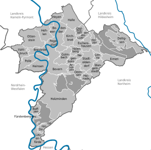
Holzminden (German pronunciation: [hɔltsˈmɪndn̩]) is a district in Lower Saxony, Germany, with the town of Holzminden as its administrative capital. It is bounded by (from the north and clockwise) the districts of Hamelin-Pyrmont, Hildesheim and Northeim, and by the state of North Rhine-Westphalia (districts of Höxter and Lippe).
History
The district was established in 1833 within the Duchy of Brunswick-Lüneburg. It was moved to the Prussian Province of Hanover as part of a territorial exchange in 1942. The last territorial modification was in 1974.
Geography
The district is located in the Weserbergland mountains, roughly between Hamelin and Göttingen. The Weser River forms the southwestern border of the district and runs through its northern parts.
Coat of arms
The lion is taken from the arms of the County of Everstein; the counts ruled over the region in the 14th century and were the founders of the City of Holzminden. The bar in the bottom is symbolising the Weser River.
Towns and municipalities
| Towns | Samtgemeinden | |
|---|---|---|
|
|
|
|
| 1seat of the Samtgemeinde; 2town | ||
Partner regions
 Głubczyce County, Poland

See also
References
- ^ "LSN-Online Regionaldatenbank, Tabelle A100001G: Fortschreibung des Bevölkerungsstandes, Stand 31. Dezember 2022" (in German). Landesamt für Statistik Niedersachsen.
External links
![]() Media related to Landkreis Holzminden at Wikimedia Commons
Media related to Landkreis Holzminden at Wikimedia Commons
- Official website (in German)
- v
- t
- e
 Urban and rural districts in the state of Lower Saxony in Germany
- Ammerland
- Aurich
- Bentheim
- Celle
- Cloppenburg
- Cuxhaven
- Diepholz
- Emsland
- Friesland
- Gifhorn
- Goslar
- Göttingen
- Hameln-Pyrmont
- Harburg
- Heidekreis
- Helmstedt
- Hildesheim
- Holzminden
- Leer
- Lüchow-Dannenberg
- Lüneburg
- Nienburg
- Northeim
- Oldenburg
- Osnabrück
- Osterholz
- Peine
- Rotenburg
- Schaumburg
- Stade
- Uelzen
- Vechta
- Verden
- Wesermarsch
- Wittmund
- Wolfenbüttel
Districts of German states (Full list)
- Baden-Württemberg
- Bavaria
- Brandenburg
- Bremen
- Hesse
- Lower Saxony
- Mecklenburg-Vorpommern
- North Rhine-Westphalia
- Rhineland-Palatinate
- Saarland
- Saxony
- Saxony-Anhalt
- Schleswig-Holstein
- Thuringia
51°50′N 9°30′E / 51.83°N 9.5°E / 51.83; 9.5
Authority control databases | |
|---|---|
| International |
|
| National |
|


