Marijampolė County
County of Lithuania
County in Lithuania
Marijampolė County Marijampolės apskritis | |
|---|---|
County | |
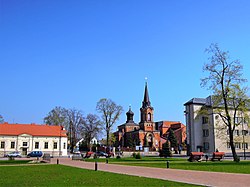 Marijampolė, the largest city in county | |
 Flag  Coat of arms | |
 Location of Marijampolė County | |
| Country |  Lithuania Lithuania |
| Administrative centre | Marijampolė |
| Municipalities | List
|
| Area | |
| • Total | 4,466 km2 (1,724 sq mi) |
| (6.8% of the area of Lithuania) | |
| Population (2016-01-20) | |
| • Total | 136,671 |
| • Rank | 6th of 10 (5.4% of the population of Lithuania) |
| • Density | 31/km2 (79/sq mi) |
| GDP | |
| • Total | €2.0 billion (2022) |
| Time zone | UTC+2 (EET) |
| • Summer (DST) | UTC+3 (EEST) |
| ISO 3166 code | LT-MR |
| HDI (2018) | 0.825[2] very high · 8th |
 | |
Marijampolė County (Lithuanian: Marijampolės apskritis) is one of the ten counties in Lithuania. It is in the south of the country in the historical Suvalkija region, and its capital is the town Marijampolė. On 1 July 2010, the county administration was abolished,[3] and since that date, Marijampolė County remains as the territorial and statistical unit.
It borders the Tauragė County in the north, Kaunas County and Alytus County in the east, Podlaskie Voivodeship of Poland in the south and Kaliningrad Oblast of Russia in the east.
Municipalities
Municipalities are:
 | Kalvarija Municipality |
 | Kazlų Rūda Municipality |
 | Marijampolė Municipality |
 | Šakiai District Municipality |
 | Vilkaviškis District Municipality |
Cities
Gallery
-
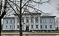
 Paežeriai Manor
 -

-

-
 Gymnasium in Marijampolė
 -
 Town Hall in Kazlų Rūda
 -
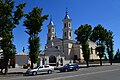 Holy Name of Mary church in Kalvarija


References
External links
- Social and demographic characteristics of Marijampolė County
- Economy of Marijampolė County
- Environment of Marijampolė County
- v
- t
- e
 Lithuania portal

Marijampolė County | ||
|---|---|---|
| Municipalities | | |
| Cities | ||
| Towns | ||
| Villages | ||
54°33′31″N 23°20′58″E / 54.55861°N 23.34944°E / 54.55861; 23.34944
| Authority control databases: Geographic |
|
|---|
 | This Marijampolė County, Lithuania location article is a stub. You can help Wikipedia by expanding it. |
- v
- t
- e


