National Register of Historic Places listings in Bladen County, North Carolina
Map all coordinates using OpenStreetMap
Download coordinates as:
- KML
- GPX (all coordinates)
- GPX (primary coordinates)
- GPX (secondary coordinates)

This list includes properties and districts listed on the National Register of Historic Places in Bladen County, North Carolina. Click the "Map of all coordinates" link to the right to view an online map of all properties and districts with latitude and longitude coordinates in the table below.[1]
This National Park Service list is complete through NPS recent listings posted June 7, 2024.[2]
| [3] | Name on the Register[4] | Image | Date listed[5] | Location | City or town | Description |
|---|---|---|---|---|---|---|
| 1 | Bladen County Training School |  | September 11, 2018 (#100002926) | 1360 Martin Luther King Jr. Dr. 34°37′15″N 78°37′06″W / 34.620833°N 78.618333°W / 34.620833; -78.618333 (Bladen County Training School) | Elizabethtown | |
| 2 | Brown Marsh Presbyterian Church | 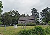 | September 2, 1975 (#75001239) | N of Clarkton on SR 1700 off SR 1762 34°31′33″N 78°38′19″W / 34.525833°N 78.638611°W / 34.525833; -78.638611 (Brown Marsh Presbyterian Church) | Clarkton | |
| 3 | Carver's Creek Methodist Church | Upload image | April 30, 2008 (#08000365) | 16904 NC 87 E. 34°27′19″N 78°24′29″W / 34.455328°N 78.408047°W / 34.455328; -78.408047 (Carver's Creek Methodist Church) | Council | |
| 4 | John Hector Clark House |  | May 20, 1987 (#87000039) | SE corner jct. of S. Grove and E. Green Sts. 34°29′19″N 78°39′15″W / 34.488611°N 78.654167°W / 34.488611; -78.654167 (John Hector Clark House) | Clarkton | |
| 5 | Clarkton Depot |  | December 23, 1986 (#86003463) | Elm and Hester Sts. 34°29′21″N 78°39′29″W / 34.489167°N 78.658056°W / 34.489167; -78.658056 (Clarkton Depot) | Clarkton | |
| 6 | Desserette | Upload image | October 7, 1987 (#87001786) | SW side of SR 1320 near jct. with SR 1318 34°47′57″N 78°46′13″W / 34.799167°N 78.770278°W / 34.799167; -78.770278 (Desserette) | White Oak | |
| 7 | Gilmore-Patterson Farm | Upload image | July 28, 1999 (#99000912) | 20337 NC 87 W 34°48′22″N 78°49′50″W / 34.806233°N 78.830442°W / 34.806233; -78.830442 (Gilmore-Patterson Farm) | St. Pauls | |
| 8 | Harmony Hall |  | March 24, 1972 (#72000925) | W of White Oak on SR 1351 34°44′24″N 78°44′21″W / 34.740025°N 78.739081°W / 34.740025; -78.739081 (Harmony Hall) | White Oak | |
| 9 | Mt. Horeb Presbyterian Church and Cemetery |  | May 13, 1987 (#87000695) | SW corner of NC 87 and SR 1712 Jct. 34°30′58″N 78°27′02″W / 34.516111°N 78.450556°W / 34.516111; -78.450556 (Mt. Horeb Presbyterian Church and Cemetery) | Elizabethtown | |
| 10 | Oakland Plantation | 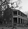 | April 25, 1972 (#72000924) | Off SR 1730 34°28′01″N 78°23′58″W / 34.467072°N 78.399522°W / 34.467072; -78.399522 (Oakland Plantation) | Carvers | |
| 11 | Purdie House and Purdie Methodist Church | Upload image | April 13, 1977 (#77000989) | 2.8 miles E of Tar Heel 34°42′42″N 78°44′48″W / 34.711667°N 78.746667°W / 34.711667; -78.746667 (Purdie House and Purdie Methodist Church) | Tar Heel | |
| 12 | South River Presbyterian Church |  | May 23, 1996 (#96000563) | NE side of NC 210, 1.7 miles SE of jct. with US 701 34°43′48″N 78°24′03″W / 34.730000°N 78.400833°W / 34.730000; -78.400833 (South River Presbyterian Church) | Garland | |
| 13 | Trinity Methodist Church |  | September 14, 1989 (#89001419) | Broad and Lower Sts. 34°37′42″N 78°36′11″W / 34.628333°N 78.603056°W / 34.628333; -78.603056 (Trinity Methodist Church) | Elizabethtown | |
| 14 | Walnut Grove | Upload image | May 29, 1975 (#75001241) | E of Tar Heel on NC 87 34°43′52″N 78°46′56″W / 34.731103°N 78.782278°W / 34.731103; -78.782278 (Walnut Grove) | Tar Heel |
See also
Wikimedia Commons has media related to National Register of Historic Places in Bladen County, North Carolina.
- National Register of Historic Places listings in North Carolina
- List of National Historic Landmarks in North Carolina
References
- ^ The latitude and longitude information provided in this table was derived originally from the National Register Information System, which has been found to be fairly accurate for about 99% of listings. Some locations in this table may have been corrected to current GPS standards.
- ^ National Park Service, United States Department of the Interior, "National Register of Historic Places: Weekly List Actions", retrieved June 7, 2024.
- ^ Numbers represent an alphabetical ordering by significant words. Various colorings, defined here, differentiate National Historic Landmarks and historic districts from other NRHP buildings, structures, sites or objects.
- ^ "National Register Information System". National Register of Historic Places. National Park Service. April 24, 2008.
- ^ The eight-digit number below each date is the number assigned to each location in the National Register Information System database, which can be viewed by clicking the number.
- v
- t
- e

by county
- Alamance
- Alexander
- Alleghany
- Anson
- Ashe
- Avery
- Beaufort
- Bertie
- Bladen
- Brunswick
- Buncombe
- Burke
- Cabarrus
- Caldwell
- Camden
- Carteret
- Caswell
- Catawba
- Chatham
- Cherokee
- Chowan
- Clay
- Cleveland
- Columbus
- Craven
- Cumberland
- Currituck
- Dare
- Davidson
- Davie
- Duplin
- Durham
- Edgecombe
- Forsyth
- Franklin
- Gaston
- Gates
- Graham
- Granville
- Greene
- Guilford
- Halifax
- Harnett
- Haywood
- Henderson
- Hertford
- Hoke
- Hyde
- Iredell
- Jackson
- Johnston
- Jones
- Lee
- Lenoir
- Lincoln
- Macon
- Madison
- Martin
- McDowell
- Mecklenburg
- Mitchell
- Montgomery
- Moore
- Nash
- New Hanover
- Northampton
- Onslow
- Orange
- Pamlico
- Pasquotank
- Pender
- Perquimans
- Person
- Pitt
- Polk
- Randolph
- Richmond
- Robeson
- Rockingham
- Rowan
- Rutherford
- Sampson
- Scotland
- Stanly
- Stokes
- Surry
- Swain
- Transylvania
- Tyrrell
- Union
- Vance
- Wake
- Warren
- Washington
- Watauga
- Wayne
- Wilkes
- Wilson
- Yadkin
- Yancey
| |
|---|---|
| Topics | |
| Lists by state |
|
| Lists by insular areas | |
| Lists by associated state | |
| Other areas | |
| Related | |
| |


