Pigeon Key Historic District
Historic district in Florida, United States
United States historic place
Pigeon Key Historic District | |
 Southern part of Pigeon Key, viewed from the old Seven Mile Bridge | |
24°42′14″N 81°9′19″W / 24.70389°N 81.15528°W / 24.70389; -81.15528 | |
| Area | 50 acres (20 ha) |
|---|---|
| NRHP reference No. | 90000443 |
| Added to NRHP | March 16, 1990 |
The Pigeon Key Historic District is a U.S. historic district (designated as such on March 16, 1990) located on Pigeon Key in Florida. The district is off U.S. 1 at mile marker 45. It contains 11 historic buildings and 3 structures. Although the old Seven Mile Bridge crosses over the island, at approximately mile marker 45, west of Knight's Key, (city of Marathon in the middle Florida Keys) and just east of Moser Channel, which is the deepest section of the seven-mile span, it and its exit ramp to the island were closed in 2008 and not reopened until 2022. While the bridge was closed, access was by ferry or private watercraft only,[1] but in 2014 FDOT approved a $77 million plan to restore it.[2] The old bridge was restored and reopened in 2022.
The island is named "Cayo Paloma" on many old Spanish charts.
The island is said to be named for large flocks of white-crowned pigeons (Columba leucocephala Linnaeus) which once roosted there.[3] During the building of Henry Flagler's Overseas Railroad Key West Extension, a major construction depot was located there, the jumping off point for construction of the Seven Mile Bridge. A number of buildings from the Flagler era remain on the island. They are now part of the Pigeon Key Historic District.
A rare three-way bridge, now partially abandoned, is located there.
Popular culture
This place was featured during the 18th-season finale as the Finish Line of the hit-reality series, The Amazing Race: Unfinished Business.
Gallery
-
 Partial view of Pigeon Key. The old Seven Mile Bridge is shown crossing the island in the background. The exit ramp is shown to the left.
 -
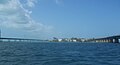 Pigeon Key, from the east. Old Seven Mile Bridge on right, new one on left
 -
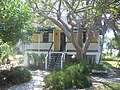 Assistant bridge tender's house
 -
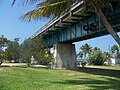
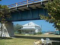 Old bridge and foreman's house
 -
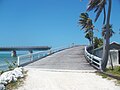 Ramp that comes off old bridge
 -
 Under ramp that comes off old bridge
 -
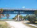 Old bridge
 -
 Old bridge


References
- ^ Toppino, Nancy (November 18, 2008). Florida Keys and Key West. Globe Pequot Press. p. 271. ISBN 9780762748716. Retrieved January 17, 2015.
- ^ Elaine, Glusac (April 3, 2014). "In the Keys, New Plans for an Old Bridge". New York Times. Retrieved January 17, 2015.
- ^ "Tiny island holds a lot of history". Keynoter Publishing Company Inc. Retrieved January 13, 2013.
External links
 Florida portal

Wikimedia Commons has media related to Pigeon Key Historic District.
- Monroe County listings at National Register of Historic Places
- Pigeon Key Foundation
- History of Pigeon Key
- Pigeon Key - Marathon Key Florida Keys Official Tourism Site Heart of the Florida Keys
- v
- t
- e
Municipalities and communities of Monroe County, Florida, United States
County seat: Key West
- Key Colony Beach
- Key West
- Layton
- Marathon

communities
- Florida portal
- United States portal
 | This article about a property in Monroe County, Florida on the National Register of Historic Places is a stub. You can help Wikipedia by expanding it. |
- v
- t
- e


