Saint-Pierre, Haute-Garonne
Commune in Occitania, France

Coat of arms
Location of Saint-Pierre

(2020–2026) Pierrette Jarnole[1]
1
(2021)[2]
31511 /31590
(avg. 218 m or 715 ft)
Saint-Pierre (French pronunciation: [sɛ̃ pjɛʁ] ⓘ; Languedocien: Sent Pèire) is a commune in the Haute-Garonne department in southwestern France.
Population
| Year | Pop. | ±% p.a. |
|---|---|---|
| 1968 | 134 | — |
| 1975 | 115 | −2.16% |
| 1982 | 135 | +2.32% |
| 1990 | 201 | +5.10% |
| 1999 | 209 | +0.43% |
| 2009 | 247 | +1.68% |
| 2014 | 264 | +1.34% |
| 2020 | 247 | −1.10% |
| Source: INSEE[3] | ||
The inhabitants of the commune are called Saint-Pierrains in French.
Monuments
-
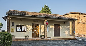 Town hall
 -
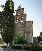 Church st.-Martin bell gable
 -
 War memorial


See also
References
- ^ "Répertoire national des élus: les maires". data.gouv.fr, Plateforme ouverte des données publiques françaises (in French). 9 August 2021.
- ^ "Populations légales 2021" (in French). The National Institute of Statistics and Economic Studies. 28 December 2023.
- ^ Population en historique depuis 1968, INSEE
Wikimedia Commons has media related to Saint-Pierre (Haute-Garonne).
- v
- t
- e
Communes of the department of Haute-Garonne 

- Agassac
- Aignes
- Aigrefeuille
- Alan
- Albiac
- Ambax
- Anan
- Antichan-de-Frontignes
- Antignac
- Arbas
- Arbon
- Ardiège
- Arguenos
- Argut-Dessous
- Arlos
- Arnaud-Guilhem
- Artigue
- Aspet
- Aspret-Sarrat
- Aucamville
- Aulon
- Auragne
- Aureville
- Auriac-sur-Vendinelle
- Auribail
- Aurignac
- Aurin
- Ausseing
- Ausson
- Aussonne
- Auterive
- Auzas
- Auzeville-Tolosane
- Auzielle
- Avignonet-Lauragais
- Ayguesvives
- Azas
- Bachas
- Bachos
- Bagiry
- Bagnères-de-Luchon
- Balesta
- Balma
- Barbazan
- Baren
- Bax
- Baziège
- Bazus
- Beauchalot
- Beaufort
- Beaumont-sur-Lèze
- Beaupuy
- Beauteville
- Beauville
- Beauzelle
- Belberaud
- Belbèze-de-Lauragais
- Belbèze-en-Comminges
- Bélesta-en-Lauragais
- Bellegarde-Sainte-Marie
- Bellesserre
- Benque
- Benque-Dessous-et-Dessus
- Bérat
- Bessières
- Bezins-Garraux
- Billière
- Binos
- Blagnac
- Blajan
- Bois-de-la-Pierre
- Boissède
- Bondigoux
- Bonrepos-Riquet
- Bonrepos-sur-Aussonnelle
- Bordes-de-Rivière
- Le Born
- Boudrac
- Bouloc
- Boulogne-sur-Gesse
- Bourg-d'Oueil
- Bourg-Saint-Bernard
- Boussan
- Boussens
- Boutx
- Bouzin
- Bragayrac
- Brax
- Bretx
- Brignemont
- Bruguières
- Burgalays
- Le Burgaud
- Buzet-sur-Tarn
- Cabanac-Cazaux
- Cabanac-Séguenville
- Le Cabanial
- Cadours
- Caignac
- Calmont
- Cambernard
- Cambiac
- Canens
- Capens
- Caragoudes
- Caraman
- Carbonne
- Cardeilhac
- Cassagnabère-Tournas
- Cassagne
- Castagnac
- Castagnède
- Castanet-Tolosan
- Castelbiague
- Castelgaillard
- Castelginest
- Castelmaurou
- Castelnau-d'Estrétefonds
- Castelnau-Picampeau
- Le Castéra
- Castéra-Vignoles
- Casties-Labrande
- Castillon-de-Larboust
- Castillon-de-Saint-Martory
- Cathervielle
- Caubiac
- Caubous
- Caujac
- Cazac
- Cazarilh-Laspènes
- Cazaril-Tambourès
- Cazaunous
- Cazaux-Layrisse
- Cazeaux-de-Larboust
- Cazeneuve-Montaut
- Cazères
- Cépet
- Cessales
- Charlas
- Chaum
- Chein-Dessus
- Ciadoux
- Cier-de-Luchon
- Cier-de-Rivière
- Cierp-Gaud
- Cintegabelle
- Cirès
- Clarac
- Clermont-le-Fort
- Colomiers
- Cornebarrieu
- Corronsac
- Coueilles
- Couladère
- Couret
- Cox
- Cugnaux
- Cuguron
- Le Cuing
- Daux
- Deyme
- Donneville
- Drémil-Lafage
- Drudas
- Eaunes
- Empeaux
- Encausse-les-Thermes
- Eoux
- Escalquens
- Escanecrabe
- Escoulis
- Espanès
- Esparron
- Esperce
- Estadens
- Estancarbon
- Esténos
- Eup
- Fabas
- Le Faget
- Falga
- Le Fauga
- Fenouillet
- Figarol
- Flourens
- Folcarde
- Fonbeauzard
- Fonsorbes
- Fontenilles
- Forgues
- Fos
- Fougaron
- Fourquevaux
- Le Fousseret
- Francarville
- Francazal
- Francon
- Franquevielle
- Le Fréchet
- Fronsac
- Frontignan-de-Comminges
- Frontignan-Savès
- Fronton
- Frouzins
- Fustignac
- Gagnac-sur-Garonne
- Gaillac-Toulza
- Galié
- Ganties
- Garac
- Gardouch
- Gargas
- Garidech
- Garin
- Gauré
- Gémil
- Génos
- Gensac-de-Boulogne
- Gensac-sur-Garonne
- Gibel
- Gouaux-de-Larboust
- Gouaux-de-Luchon
- Goudex
- Gourdan-Polignan
- Goutevernisse
- Gouzens
- Goyrans
- Gragnague
- Gratens
- Gratentour
- Grazac
- Grenade
- Grépiac
- Le Grès
- Guran
- Herran
- His
- Huos
- L'Isle-en-Dodon
- Issus
- Izaut-de-l'Hôtel
- Jurvielle
- Juzes
- Juzet-de-Luchon
- Juzet-d'Izaut
- Labarthe-Inard
- Labarthe-Rivière
- Labarthe-sur-Lèze
- Labastide-Beauvoir
- Labastide-Clermont
- Labastide-Paumès
- Labastide-Saint-Sernin
- Labastidette
- Labège
- Labroquère
- Labruyère-Dorsa
- Lacaugne
- Lacroix-Falgarde
- Laffite-Toupière
- Lafitte-Vigordane
- Lagarde
- Lagardelle-sur-Lèze
- Lagrâce-Dieu
- Lagraulet-Saint-Nicolas
- Lahage
- Lahitère
- Lalouret-Laffiteau
- Lamasquère
- Landorthe
- Lanta
- Lapeyrère
- Lapeyrouse-Fossat
- Larcan
- Laréole
- Larra
- Larroque
- Lasserre-Pradère
- Latoue
- Latour
- Latrape
- Launac
- Launaguet
- Lautignac
- Lauzerville
- Lavalette
- Lavelanet-de-Comminges
- Lavernose-Lacasse
- Layrac-sur-Tarn
- Lécussan
- Lège
- Léguevin
- Lescuns
- Lespinasse
- Lespiteau
- Lespugue
- Lestelle-de-Saint-Martory
- Lévignac
- Lherm
- Lieoux
- Lilhac
- Lodes
- Longages
- Loubens-Lauragais
- Loudet
- Lourde
- Luscan
- Lussan-Adeilhac
- Lux
- La Magdelaine-sur-Tarn
- Mailholas
- Malvezie
- Mancioux
- Mane
- Marignac
- Marignac-Lasclares
- Marignac-Laspeyres
- Marliac
- Marquefave
- Marsoulas
- Martisserre
- Martres-de-Rivière
- Martres-Tolosane
- Mascarville
- Massabrac
- Mauran
- Mauremont
- Maurens
- Mauressac
- Maureville
- Mauvaisin
- Mauvezin
- Mauzac
- Mayrègne
- Mazères-sur-Salat
- Melles
- Menville
- Mérenvielle
- Mervilla
- Merville
- Milhas
- Mirambeau
- Miramont-de-Comminges
- Miremont
- Mirepoix-sur-Tarn
- Molas
- Moncaup
- Mondavezan
- Mondilhan
- Mondonville
- Mondouzil
- Monès
- Monestrol
- Mons
- Montaigut-sur-Save
- Montastruc-de-Salies
- Montastruc-la-Conseillère
- Montastruc-Savès
- Montauban-de-Luchon
- Montaut
- Montberaud
- Montbernard
- Montberon
- Montbrun-Bocage
- Montbrun-Lauragais
- Montclar-de-Comminges
- Montclar-Lauragais
- Mont-de-Galié
- Montégut-Bourjac
- Montégut-Lauragais
- Montespan
- Montesquieu-Guittaut
- Montesquieu-Lauragais
- Montesquieu-Volvestre
- Montgaillard-de-Salies
- Montgaillard-Lauragais
- Montgaillard-sur-Save
- Montgazin
- Montgeard
- Montgiscard
- Montgras
- Montjoire
- Montlaur
- Montmaurin
- Montoulieu-Saint-Bernard
- Montoussin
- Montpitol
- Montrabé
- Montréjeau
- Montsaunès
- Mourvilles-Basses
- Mourvilles-Hautes
- Moustajon
- Muretsubpr
- Nailloux
- Nénigan
- Nizan-Gesse
- Noé
- Nogaret
- Noueilles
- Odars
- Ondes
- Oô
- Ore
- Palaminy
- Paulhac
- Payssous
- Péchabou
- Pechbonnieu
- Pechbusque
- Péguilhan
- Pelleport
- Peyrissas
- Peyrouzet
- Peyssies
- Pibrac
- Pin-Balma
- Le Pin-Murelet
- Pinsaguel
- Pins-Justaret
- Plagne
- Plagnole
- Plaisance-du-Touch
- Le Plan
- Pointis-de-Rivière
- Pointis-Inard
- Polastron
- Pompertuzat
- Ponlat-Taillebourg
- Portet-d'Aspet
- Portet-de-Luchon
- Portet-sur-Garonne
- Poubeau
- Poucharramet
- Pouy-de-Touges
- Pouze
- Préserville
- Proupiary
- Prunet
- Puydaniel
- Puymaurin
- Puysségur
- Quint-Fonsegrives
- Ramonville-Saint-Agne
- Razecueillé
- Rebigue
- Régades
- Renneville
- Revel
- Rieucazé
- Rieumajou
- Rieumes
- Rieux-Volvestre
- Riolas
- Roquefort-sur-Garonne
- Roques
- Roquesérière
- Roquettes
- Rouède
- Rouffiac-Tolosan
- Roumens
- Sabonnères
- Saccourvielle
- Saiguède
- Saint-Alban
- Saint-André
- Saint-Araille
- Saint-Aventin
- Saint-Béat-Lez
- Saint-Bertrand-de-Comminges
- Saint-Cézert
- Saint-Christaud
- Saint-Clar-de-Rivière
- Sainte-Foy-d'Aigrefeuille
- Sainte-Foy-de-Peyrolières
- Sainte-Livrade
- Saint-Élix-le-Château
- Saint-Élix-Séglan
- Saint-Félix-Lauragais
- Saint-Ferréol-de-Comminges
- Saint-Frajou
- Saint-Gaudenssubpr
- Saint-Geniès-Bellevue
- Saint-Germier
- Saint-Hilaire
- Saint-Ignan
- Saint-Jean
- Saint-Jean-Lherm
- Saint-Jory
- Saint-Julia
- Saint-Julien-sur-Garonne
- Saint-Lary-Boujean
- Saint-Laurent
- Saint-Léon
- Saint-Loup-Cammas
- Saint-Loup-en-Comminges
- Saint-Lys
- Saint-Mamet
- Saint-Marcel-Paulel
- Saint-Marcet
- Saint-Martory
- Saint-Médard
- Saint-Michel
- Saint-Orens-de-Gameville
- Saint-Paul-d'Oueil
- Saint-Paul-sur-Save
- Saint-Pé-d'Ardet
- Saint-Pé-Delbosc
- Saint-Pierre
- Saint-Pierre-de-Lages
- Saint-Plancard
- Saint-Rome
- Saint-Rustice
- Saint-Sauveur
- Saint-Sulpice-sur-Lèze
- Saint-Thomas
- Saint-Vincent
- Sajas
- Saleich
- Salerm
- Salies-du-Salat
- Salles-et-Pratviel
- Salles-sur-Garonne
- La Salvetat-Lauragais
- La Salvetat-Saint-Gilles
- Saman
- Samouillan
- Sana
- Sarrecave
- Sarremezan
- Saubens
- Saussens
- Sauveterre-de-Comminges
- Saux-et-Pomarède
- Savarthès
- Savères
- Sédeilhac
- Ségreville
- Seilh
- Seilhan
- Sénarens
- Sengouagnet
- Sepx
- Seyre
- Seysses
- Signac
- Sode
- Soueich
- Tarabel
- Terrebasse
- Thil
- Touille
- Toulousepref
- Tournefeuille
- Les Tourreilles
- Toutens
- Trébons-de-Luchon
- Trébons-sur-la-Grasse
- L'Union
- Urau
- Vacquiers
- Valcabrère
- Valentine
- Vallègue
- Vallesvilles
- Varennes
- Vaudreuille
- Vaux
- Vendine
- Venerque
- Verfeil
- Vernet
- Vieille-Toulouse
- Vieillevigne
- Vignaux
- Vigoulet-Auzil
- Villariès
- Villate
- Villaudric
- Villefranche-de-Lauragais
- Villematier
- Villemur-sur-Tarn
- Villeneuve-de-Rivière
- Villeneuve-Lécussan
- Villeneuve-lès-Bouloc
- Villeneuve-Tolosane
- Villenouvelle
- pref: prefecture
- subpr: subprefecture
| Authority control databases: National |
|
|---|
 | This Haute-Garonne geographical article is a stub. You can help Wikipedia by expanding it. |
- v
- t
- e


