Surberg
Municipality in Bavaria, Germany

Coat of arms
Location of Surberg within Traunstein district
(2020–26) Michael Wimmer[1]
(2022-12-31)[2]
83362
Surberg is a municipality in the district of Traunstein in Bavaria, Germany. It is 90 km (55.7 miles) southeast of the Bavarian capital of Munich.[3]
Sights
- Catholic parish church St. Georg
- Surberg Inn
-
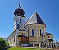 Parish church St. Georg
 -
 Interior of St. Georg
 -
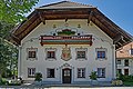 Surberg Inn


References
- ^ Liste der ersten Bürgermeister/Oberbürgermeister in kreisangehörigen Gemeinden, Bayerisches Landesamt für Statistik, 15 July 2021.
- ^ Genesis Online-Datenbank des Bayerischen Landesamtes für Statistik Tabelle 12411-003r Fortschreibung des Bevölkerungsstandes: Gemeinden, Stichtag (Einwohnerzahlen auf Grundlage des Zensus 2011) (Hilfe dazu).
- ^ "Municipality Surberg", Places in Germany.http://www.places-in-germany.com/24782-municipality-surberg.html
- v
- t
- e
Towns and municipalities in Traunstein (district)
- Altenmarkt an der Alz
- Bergen
- Chieming
- Engelsberg
- Fridolfing
- Grabenstätt
- Grassau
- Inzell
- Kienberg
- Kirchanschöring
- Marquartstein
- Nußdorf
- Obing
- Palling
- Petting
- Pittenhart
- Reit im Winkl
- Ruhpolding
- Schleching
- Schnaitsee
- Seeon-Seebruck
- Siegsdorf
- Staudach-Egerndach
- Surberg
- Tacherting
- Taching am See
- Tittmoning
- Traunreut
- Traunstein
- Trostberg
- Übersee
- Unterwössen
- Vachendorf
- Waging am See
- Wonneberg

 | This Traunstein district location article is a stub. You can help Wikipedia by expanding it. |
- v
- t
- e
Authority control databases | |
|---|---|
| International |
|
| National |
|


