Tangle Ridge
Mountain ridge in Jasper NP, Alberta, Canada


Tangle Ridge
Location of Tangle Ridge in Alberta
Show map of Alberta
Tangle Ridge
Tangle Ridge (Canada)
Show map of CanadaTangle Ridge is a 3,001-metre (9,846 ft) mountain summit located in Jasper National Park, in the Canadian Rockies of Alberta, Canada. Tangle Ridge is situated south of Beauty Creek and north of Tangle Creek, in the Sunwapta River valley. Topographic relief is significant as the summit rises 1,200 metres (3,937 ft) above Beauty Creek in 2 km (1.2 mi). Views from the top of Tangle Ridge provide photographers with an opportunity to capture the peaks surrounding the Columbia Icefield, some of which, such as Mount Columbia and Mount Alberta, are otherwise hidden from view along the Icefields Parkway.
History
The mountain was named by Mary Schäffer in 1907 for the difficulty that climbers had descending down Tangle Creek from the ridge.[2] The mountain's toponym was officially adopted in 1935 by the Geographical Names Board of Canada.[4]
Climate
Based on the Köppen climate classification, Tangle Ridge is located in a subarctic climate zone with cold, snowy winters, and mild summers.[6] Winter temperatures can drop below −20 °C (−4 °F) with wind chill factors below −30 °C (−22 °F). Weather conditions during winter make Tangle Ridge one of the better places in the Rockies for ice climbing. Precipitation runoff from Tangle Ridge drains into the Sunwapta River which is a tributary of the Athabasca River.
Geology
Tangle Ridge is composed of sedimentary rock laid down from the Precambrian to Jurassic periods.[7] Formed in shallow seas, this sedimentary rock was pushed east and over the top of younger rock during the Laramide orogeny.[8]
Ice Climbing Routes
Ice Climbing Routes with grades on Tangle Ridge:
- Shades of Beauty – WI4[9]
- Tangle Falls – WI2-3[10]
- The Stage – WI3-4[11]
- The Wings – WI3-4[12]
- Curtain Call – WI6[13]
- Cyber Pasty Memorial – WI5+[14]
- Melt Out – WI3[15]
- Rick Blak Memorial Route – WI5[16]
Tangle Falls
Tangle Falls is a multi-tiered cascade that might be the most often photographed waterfall alongside the Icefields Parkway because of its easy access.[17] Height: 30 metres (98 ft) Width: 12 metres (39 ft) Coordinates: N 52° 16.035 W 117° 17.197[18]
See also
Gallery
-
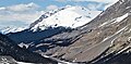
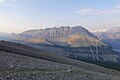
 View looking south from Tangle Ridge
 -
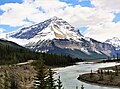
 Tangle Ridge (left), Mt. Kitchener (right) and Sunwapta River as seen from the Icefields Parkway
 -
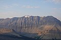
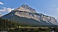 Northwest aspect of Tangle Ridge from Icefields Parkway
 -
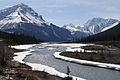
 Tangle Ridge and Sunwapta River
 -
 Tangle Ridge from the south
 -
 North aspect from Sunwapta Peak
 -
 North face
 -
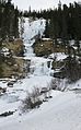 Tangle Falls in winter
 -
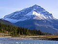 Tangle Ridge and Sunwapta River


References
- ^ "Topographic map of Tangle Ridge". opentopomap.org. Retrieved 2023-03-26.
- ^ a b "Tangle Ridge". cdnrockiesdatabases.ca. Retrieved 2019-06-08.
- ^ a b "Tangle Peak". Bivouac.com. Retrieved 2018-10-21.
- ^ a b c "Tangle Ridge". Geographical Names Data Base. Natural Resources Canada. Retrieved 2018-10-21.
- ^ Kane, Alan (1999). "Tangle Ridge". Scrambles in the Canadian Rockies. Calgary: Rocky Mountain Books. p. 311. ISBN 0-921102-67-4.
- ^ Peel, M. C.; Finlayson, B. L. & McMahon, T. A. (2007). "Updated world map of the Köppen−Geiger climate classification". Hydrol. Earth Syst. Sci. 11: 1633–1644. ISSN 1027-5606.
- ^ Belyea, Helen R. (1960). The Story of the Mountains in Banff National Park (PDF). parkscanadahistory.com (Report). Ottawa: Geological Survey of Canada. Archived (PDF) from the original on 2015-10-02. Retrieved 2019-09-13.
- ^ Gadd, Ben (2008). "Geology of the Rocky Mountains and Columbias" (PDF).
- ^ Shades of Beauty Archived 2018-10-22 at the Wayback Machine SummitPost
- ^ Tangle Falls Archived 2018-10-22 at the Wayback Machine Mountain Project
- ^ The Stage Archived 2018-10-22 at the Wayback Machine Mountain Project
- ^ The Wings Archived 2018-10-22 at the Wayback Machine Mountain Project
- ^ Curtain Call Archived 2018-10-22 at the Wayback Machine Mountain Project
- ^ Cyber Pasty Memorial Archived 2018-10-22 at the Wayback Machine Mountain Project
- ^ Melt Out Archived 2018-10-22 at the Wayback Machine Mountain Project
- ^ Rick Blak Memorial Route Archived 2018-10-22 at the Wayback Machine SummitPost
- ^ "Tangle Falls". World Waterfall Database. Archived from the original on 2018-10-22.
- ^ Tangle Falls Archived 2018-10-22 at the Wayback Machine Waymarking
External links
- Weather forecast: Tangle Ridge
- Parks Canada web site: Jasper National Park
Places adjacent to Tangle Ridge | ||||||||||||||||
|---|---|---|---|---|---|---|---|---|---|---|---|---|---|---|---|---|
| ||||||||||||||||


- v
- t
- e
- Ball
- Bare
- Beaverfoot
- Blue
- Bow
- Crowsnest
- Elk
- Fairholme
- Fiddle
- Flathead
- Foothills
- High Rock
- Kananaskis
- Livingstone
- Lizard
- Maligne
- Massive
- Misty
- Morrissey
- Palliser
- President
- Queen Elizabeth
- Rainbow
- Ram
- Sawback
- Sentinel
- Slate
- South Jasper
- Sundance
- Terminal
- Tower of London
- Vermilion
- Victoria Cross
- Waputik
- Winston Churchill
- Continental Ranges
- Hart Ranges
- Muskwa Ranges
- Alberta
- Andromeda
- Assiniboine
- Athabasca
- Brazeau
- Bryce
- Cascade
- Castle
- Castleguard
- Clemenceau
- Columbia
- Cory
- Edith Cavell
- Forbes
- Hector
- Hosmer
- Hungabee
- Joffre
- Kitchener
- Lyell
- Heart
- Pilot
- Pyramid
- Resplendent
- Robson
- Rundle
- Sarbach
- Saskatchewan
- Smythe
- Snow Dome
- Stanley Peak
- Sulphur
- Temple
- Three Sisters
- Trinity
- Twin
- Ulysses
- Unnamed Alberta–BC mountain (formerly Mount Pétain)
- Whymper
see List of rivers of the Canadian Rockies and Category:Rivers of the Canadian Rockies
- Mountain Stoney
- Mountain Metis
| International | |
|---|---|
| National |
|
| Provincial (AB) |
|
| Provincial (BC) |
- See also
- Geography portal
- Canada portal


