Thicktail chub
Species of fish
| Thicktail chub | |
|---|---|
 | |
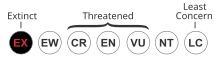
Conservation status | |
| Scientific classification | |
| Domain: | Eukaryota |
| Kingdom: | Animalia |
| Phylum: | Chordata |
| Class: | Actinopterygii |
| Order: | Cypriniformes |
| Family: | Cyprinidae |
| Genus: | Gila |
| Species: | †G. crassicauda |
| Binomial name | |
| †Gila crassicauda (S. F. Baird & Girard in Girard, 1854) | |
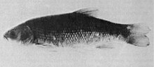
The thicktail chub (Gila crassicauda) was a type of minnow that inhabited the lowlands and weedy backwaters of the Sacramento and San Joaquin Rivers in the Central Valley of California. It was once abundant in lowland lakes, marshes, ponds, slow-moving stretches of river,[2] and, during years of heavy run-off, the surface waters of San Francisco Bay.[2] The thicktail chub was one of the most common fish in California.[2] Within Native American middens it represented 40% of the fish.[3]
The chub was a favored food of the indigenous peoples of Clear Lake and the Central Valley before being heavily exploited by commercial fishermen supplying the San Francisco market.[2] A heavy-bodied fish with a thick tail and a small, cone-shaped head, the backs of the thicktail chub ranged in color from greenish brown to purplish black, while the sides and belly were yellow. It could reach a length of nearly ten inches. Although little is known about its behavior, it was probably carnivorous, feeding on small fish and invertebrates.
The primary cause of the thicktailed chub's extinction was the conversion of much of the Central Valley to agricultural use. Most of its habitat was destroyed by the drainage of sloughs and marshes, dam-building, and water diversion for irrigation. All this resulted in the loss of the sluggish water the species preferred. Competition from exotic species also contributed to its extinction. The last known example was caught on April 16, 1957.[2]
References
- ^ NatureServe (2021) [amended version of 2013 assessment]. "Gila crassicauda". IUCN Red List of Threatened Species. 2021: e.T9183A207441342. doi:10.2305/IUCN.UK.2021-3.RLTS.T9183A207441342.en. Retrieved 19 May 2024.
- ^ a b c d e Miller, Robert R.; Williams, James D.; Williams, Jack E. (1989). "Extinctions of North American Fishes During the past Century" (PDF). Fisheries. 14 (6): 22–38. doi:10.1577/1548-8446(1989)014<0022:EONAFD>2.0.CO;2. hdl:2027.42/141989.
- ^ Schulz, P.D. (1979). "Fish remains from a historic central California Indian village". Calif. Fish Game. 65: 273–276.
- v
- t
- e

- Major
- San Francisco Bay
- Suisun Bay
- San Pablo Bay
- Minor
- Golden Gate
- Grizzly Bay
- Richardson Bay
- San Rafael Bay
- Richmond Inner Harbor
- San Leandro Bay
- Former
- Yerba Buena Cove
- Mission Bay
- Rivers
- San Joaquin
- Sacramento
- Napa
- Guadalupe
- Petaluma
- Creeks (discharging into the Bay)
- Alameda
- Baxter
- Cerrito
- Codornices
- Coyote (Santa Clara)
- Coyote (Marin)
- San Leandro
- San Lorenzo
- Schoolhouse
- Temescal
- Sausal
- Redwood
- San Mateo
- Sonoma
- Corte Madera
- Arroyo Corte Madera del Presidio
- San Rafael
- Miller
- Novato
- Tolay
- San Francisquito
- Pacheco
- Alhambra
- Adobe
- Rodeo
- Refugio
- Pinole
- Garrity
- Rheem
- Karlson
- San Pablo
- Castro
- Wildcat
- Fluvius Innominatus
- Marin (Alameda County)
- Strawberry
- Easton
- Mission Creek
- Reservoirs
- Calaveras Reservoir
- Lafayette Reservoir
- Straits and estuaries
- Clifton Court Forebay
- Carquinez Strait
- Oakland Estuary
- Raccoon Strait
- Sacramento–San Joaquin River Delta
- Stockton Deepwater Shipping Channel
- Watersheds
- Laguna Creek Watershed
- Guadalupe watershed
protected areas
- Don Edwards National Wildlife Refuge
- San Pablo Bay National Wildlife Refuge
- Eden Landing Ecological Reserve
- Hayward Regional Shoreline
- Hayward Shoreline Interpretive Center
- Crown Memorial State Beach
- McLaughlin Eastshore State Park
- Emeryville Crescent State Marine Reserve
- Point Isabel Regional Shoreline
- César Chávez Park
- Brooks Island Regional Preserve
- Point Pinole Regional Shoreline
- Antioch Dunes National Wildlife Refuge
- Coyote Point Recreation Area
- Middle Harbor Shoreline Park
- National Estuarine Research Reserve
- China Camp State Park
- San Francisco Maritime National Historical Park
- SF Bay Trail
- Oyster Bay Regional Shoreline
- Big Break Regional Shoreline
- Palo Alto Baylands Nature Preserve
peninsulas
- Major islands
- Alameda
- Alcatraz
- Angel
- Treasure Island
- Yerba Buena
- Minor
- Brooks
- Bair
- Bay Farm
- Belvedere
- Brother
- Castro Rocks
- Coast Guard
- Greco
- Hooks Island
- Mare
- Red Rock
- The Sisters
- Marin Islands
- Roe
- Ryer
- Seal Islands
- Peninsulas/infill
- Albany Bulb
- Brisbane Baylands
- Point Isabel
- Foster City
- Fleming Point
- Hunters Point
- Sierra Point
- Steamboat Point
and tubes
marinas
- History
- Delta and Dawn
- Discovery Site
- Humphrey the Whale
- San Leandro Oyster Beds
- Richmond Shipyards
- U.S. Army Corps of Engineers Bay Model
- Harold Gilliam
- Marincello
- Ecology
- Golden Gate Biosphere Reserve
- Cosco Busan oil spill
- Thicktail chub
- Delta smelt
- Conservation and Development Commission
- The Watershed Project
- Save The Bay
- Citizens for East Shore Parks
- Friends of Five Creeks
- Urban Creeks Council
- 1971 oil spill
- Greenbelt Alliance
- The Bay Institute
- Reber Plan
- San Francisco Baykeeper
- San Francisco Estuary and Watershed Science
- Estuary Partnership
- Transportation
- Water Trail
- Transportation in the San Francisco Bay Area
 Portal
 Category


