Akatsi
District capital in Volta Region, Ghana
Akatsi Mornenu | |
|---|---|
District capital | |
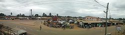 Aerial view of roads leading to Accra, Dzodze and Aflao (from left) | |
| 06°07′51.68″N 00°47′53.56″E / 6.1310222°N 0.7982111°E / 6.1310222; 0.7982111 | |
| Country |  Ghana Ghana |
| Region | Volta Region |
| District | Akatsi South District |
| Time zone | GMT |
| • Summer (DST) | GMT |
| Area code | 0966 |
Akatsi is a small town and is the capital of Akatsi South District, a district in the Volta Region of Ghana.[1]
Economy
Economic activities in Akatsi are mainly Subsistence agriculture coupled with vibrant buying and selling. Smuggling of clothing from Lomé in Togo through Aflao (the south-eastern border town of Ghana) to Accra.[citation needed] The trans-West Africa highway linking Lomé to Accra through Akatsi also aids an active male dominated transportation business in Akatsi.
Demographics
The inhabitants of Akatsi are Avenor Ewes and the main language of any social and economic interaction is Ewe. The Ewe settled in the area after the exodus of Ewe tribe from Notsie in Togo to this area in the seventeenth century.
Education
Akatsi is home to the teacher training educational institution Akatsi College of Education, which includes over 700 students and has achieved a good reputation in the area for educating tutors.
Climate
| Climate data for Akatsi (1991–2020) | |||||||||||||
|---|---|---|---|---|---|---|---|---|---|---|---|---|---|
| Month | Jan | Feb | Mar | Apr | May | Jun | Jul | Aug | Sep | Oct | Nov | Dec | Year |
| Record high °C (°F) | 38.0 (100.4) | 38.7 (101.7) | 37.8 (100.0) | 38.0 (100.4) | 37.5 (99.5) | 36.0 (96.8) | 34.2 (93.6) | 36.6 (97.9) | 34.7 (94.5) | 35.5 (95.9) | 36.0 (96.8) | 36.0 (96.8) | 38.7 (101.7) |
| Mean daily maximum °C (°F) | 34.0 (93.2) | 35.0 (95.0) | 34.4 (93.9) | 33.7 (92.7) | 32.5 (90.5) | 30.5 (86.9) | 29.4 (84.9) | 29.5 (85.1) | 30.8 (87.4) | 31.9 (89.4) | 33.0 (91.4) | 33.5 (92.3) | 32.4 (90.3) |
| Daily mean °C (°F) | 28.7 (83.7) | 29.9 (85.8) | 29.7 (85.5) | 29.3 (84.7) | 28.4 (83.1) | 27.0 (80.6) | 26.2 (79.2) | 26.1 (79.0) | 27.0 (80.6) | 27.7 (81.9) | 28.4 (83.1) | 28.7 (83.7) | 28.1 (82.6) |
| Mean daily minimum °C (°F) | 23.5 (74.3) | 24.8 (76.6) | 25.0 (77.0) | 24.8 (76.6) | 24.3 (75.7) | 23.6 (74.5) | 23.0 (73.4) | 22.5 (72.5) | 23.1 (73.6) | 23.4 (74.1) | 23.8 (74.8) | 23.7 (74.7) | 23.8 (74.8) |
| Record low °C (°F) | 18.0 (64.4) | 18.3 (64.9) | 20.0 (68.0) | 20.5 (68.9) | 20.4 (68.7) | 20.4 (68.7) | 19.5 (67.1) | 19.5 (67.1) | 20.5 (68.9) | 20.0 (68.0) | 19.5 (67.1) | 17.0 (62.6) | 17.0 (62.6) |
| Average precipitation mm (inches) | 13.5 (0.53) | 25.6 (1.01) | 83.7 (3.30) | 94.2 (3.71) | 176.2 (6.94) | 153.5 (6.04) | 56.2 (2.21) | 31.6 (1.24) | 91.0 (3.58) | 120.2 (4.73) | 73.4 (2.89) | 28.8 (1.13) | 947.9 (37.32) |
| Average precipitation days (≥ 1.0 mm) | 1.0 | 2.2 | 4.8 | 5.3 | 9.5 | 9.5 | 4.8 | 3.3 | 7.3 | 8.8 | 6.5 | 2.3 | 65.3 |
| Source: NOAA[2] | |||||||||||||
References
- ^ "Akatsi District". Archived from the original on 2012-05-11. Retrieved 2012-07-15.
- ^ "Akatsi Normals 1991–2020". World Meteorological Organization Climatological Standard Normals (1991–2020). National Oceanic and Atmospheric Administration. Archived from the original on 28 September 2023. Retrieved 28 September 2023.
External links
- AIDS education in Akatsi, Ghana – Site about an educational project in the Akatsi District, including photos and videos
- v
- t
- e
District capitals in Ghana


This Volta Region location article is a stub. You can help Wikipedia by expanding it. |
- v
- t
- e


