National Register of Historic Places listings in Jerome County, Idaho

This is a list of the National Register of Historic Places listings in Jerome County, Idaho.
This is intended to be a complete list of the properties on the National Register of Historic Places in Jerome County, Idaho, United States. Latitude and longitude coordinates are provided for many National Register properties and districts; these locations may be seen together in a map.[1]
There are 66 properties listed on the National Register in the county. More can be added; properties and districts nationwide are added to the Register weekly.[2]
This National Park Service list is complete through NPS recent listings posted June 28, 2024.[3]
Map all coordinates using OpenStreetMap
Download coordinates as:
- KML
- GPX (all coordinates)
- GPX (primary coordinates)
- GPX (secondary coordinates)
Current listings
| [4] | Name on the Register[5] | Image | Date listed[6] | Location | City or town | Description |
|---|---|---|---|---|---|---|
| 1 | Allton Building | Upload image | September 8, 1983 (#83002299) | 160 E. Main St. 42°43′28″N 114°30′58″W / 42.724444°N 114.516111°W / 42.724444; -114.516111 (Allton Building) | Jerome | |
| 2 | Tom Barnes Barn | Upload image | September 8, 1983 (#83002317) | East of Jerome 42°39′53″N 114°17′46″W / 42.664722°N 114.296111°W / 42.664722; -114.296111 (Tom Barnes Barn) | Jerome | |
| 3 | Bethune-Ayres House | Upload image | September 8, 1983 (#83002318) | East of Jerome 42°41′00″N 114°21′50″W / 42.683333°N 114.363889°W / 42.683333; -114.363889 (Bethune-Ayres House) | Jerome | |
| 4 | Carl Blessing Outbuildings | Upload image | September 8, 1983 (#83002319) | Northwest of Jerome 42°45′11″N 114°35′26″W / 42.753056°N 114.590556°W / 42.753056; -114.590556 (Carl Blessing Outbuildings) | Jerome | |
| 5 | James Bothwell Water Tank House |  | September 8, 1983 (#83002320) | North of Jerome 42°46′06″N 114°31′00″W / 42.768333°N 114.516667°W / 42.768333; -114.516667 (James Bothwell Water Tank House) | Jerome | |
| 6 | Charles Bower House | Upload image | September 8, 1983 (#83002321) | North of Jerome 42°48′58″N 114°32′14″W / 42.816111°N 114.537222°W / 42.816111; -114.537222 (Charles Bower House) | Jerome | |
| 7 | Frank J. Brick House |  | September 8, 1983 (#83002322) | 300 N. Fillmore St. 42°43′35″N 114°30′28″W / 42.726389°N 114.507778°W / 42.726389; -114.507778 (Frank J. Brick House) | Jerome | |
| 8 | Caldron Linn | 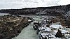 | June 27, 1972 (#72000442) | 2 miles east of Murtaugh and 6 Miles south of Hazelton, Idaho 42°29′53″N 114°09′46″W / 42.498056°N 114.162778°W / 42.498056; -114.162778 (Caldron Linn) | Murtaugh and Hazelton | Extends into Twin Falls County |
| 9 | Dick Callen House |  | September 8, 1983 (#83002323) | South of Jerome 42°40′36″N 114°31′02″W / 42.676667°N 114.517222°W / 42.676667; -114.517222 (Dick Callen House) | Jerome | |
| 10 | Canyonside School |  | October 14, 1983 (#83003579) | South of Jerome 42°40′00″N 114°31′05″W / 42.666667°N 114.518056°W / 42.666667; -114.518056 (Canyonside School) | Jerome | |
| 11 | William H. Cook Water Tank House |  | September 8, 1983 (#83004211) | Southeast of Jerome 42°40′00″N 114°24′25″W / 42.666667°N 114.406944°W / 42.666667; -114.406944 (William H. Cook Water Tank House) | Jerome | |
| 12 | E. V. Cooke House | Upload image | September 8, 1983 (#83002324) | Northeast of Jerome 42°45′19″N 114°28′16″W / 42.755278°N 114.471111°W / 42.755278; -114.471111 (E. V. Cooke House) | Jerome | |
| 13 | O. J. Daniels House |  | September 8, 1983 (#83002325) | South of Jerome 42°39′16″N 114°31′04″W / 42.654444°N 114.517778°W / 42.654444; -114.517778 (O. J. Daniels House) | Jerome | |
| 14 | George V. Doughty House and Garage | 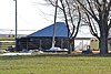 | September 15, 1983 (#83002326) | Northeast of Jerome 42°46′58″N 114°28′40″W / 42.782778°N 114.477778°W / 42.782778; -114.477778 (George V. Doughty House and Garage) | Jerome | The house has been demolished, but the garage is still standing. |
| 15 | George Epperson House |  | September 8, 1983 (#83002354) | Southeast of Jerome 42°40′12″N 114°27′47″W / 42.67°N 114.463056°W / 42.67; -114.463056 (George Epperson House) | Jerome | |
| 16 | G. H. Erdman House | Upload image | September 8, 1983 (#83002353) | West of Jerome 42°43′31″N 114°36′06″W / 42.725278°N 114.601667°W / 42.725278; -114.601667 (G. H. Erdman House) | Jerome | |
| 17 | Falls City School House | 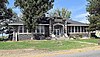 | September 8, 1983 (#83002352) | Southeast of Jerome 42°40′51″N 114°25′24″W / 42.680833°N 114.423333°W / 42.680833; -114.423333 (Falls City School House) | Jerome | |
| 18 | Merritt Fry Farm |  | September 8, 1983 (#83002351) | West of Jerome 42°41′58″N 114°36′51″W / 42.699444°N 114.614167°W / 42.699444; -114.614167 (Merritt Fry Farm) | Jerome | |
| 19 | E. C. Gleason House |  | September 8, 1983 (#83002350) | 209 E. Ave. A 42°43′22″N 114°30′54″W / 42.722778°N 114.515°W / 42.722778; -114.515 (E. C. Gleason House) | Jerome | |
| 20 | Hugh and Susie Goff House | Upload image | September 8, 1983 (#83002349) | Northeast of Jerome 42°48′42″N 114°28′19″W / 42.811667°N 114.471944°W / 42.811667; -114.471944 (Hugh and Susie Goff House) | Jerome | |
| 21 | Lulu Graves Farm | Upload image | September 8, 1983 (#83002348) | Northwest of Jerome 42°45′34″N 114°32′15″W / 42.759444°N 114.5375°W / 42.759444; -114.5375 (Lulu Graves Farm) | Jerome | |
| 22 | Greenwood School |  | July 27, 2020 (#100005364) | 2398 East 990 South 42°34′35″N 114°03′00″W / 42.5765°N 114.0499°W / 42.5765; -114.0499 (Greenwood School) | Hazelton | |
| 23 | Edward M. Gregg Farm | Upload image | September 8, 1983 (#83002347) | Southeast of Jerome 42°40′49″N 114°30′02″W / 42.680278°N 114.500556°W / 42.680278; -114.500556 (Edward M. Gregg Farm) | Jerome | |
| 24 | Bert and Fay Havens House | Upload image | September 8, 1983 (#83002346) | North of Hazelton 42°36′18″N 114°07′58″W / 42.605°N 114.132778°W / 42.605; -114.132778 (Bert and Fay Havens House) | Hazelton | |
| 25 | Hazelton Presbyterian Church | 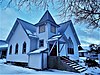 | April 26, 1991 (#91000459) | 310 Park Ave. 42°35′42″N 114°08′05″W / 42.595°N 114.134722°W / 42.595; -114.134722 (Hazelton Presbyterian Church) | Hazelton | |
| 26 | Heuer Well House/Water Tank |  | September 8, 1983 (#83002345) | Northeast of Jerome 42°46′02″N 114°26′38″W / 42.767222°N 114.443889°W / 42.767222; -114.443889 (Heuer Well House/Water Tank) | Jerome | |
| 27 | Jerome City Pump House |  | September 8, 1983 (#83002344) | 600 block of E. B St. 42°43′22″N 114°30′32″W / 42.722778°N 114.508889°W / 42.722778; -114.508889 (Jerome City Pump House) | Jerome | It is a water works building built in 1922 by stonemason H.T. Pugh. |
| 28 | Jerome Cooperative Creamery |  | September 8, 1983 (#83002338) | 313 S. Birch St. 42°43′21″N 114°31′18″W / 42.7225°N 114.521667°W / 42.7225; -114.521667 (Jerome Cooperative Creamery) | Jerome | |
| 29 | Jerome County Courthouse |  | September 28, 1987 (#87001600) | N. Lincoln 42°43′36″N 114°31′01″W / 42.726667°N 114.516944°W / 42.726667; -114.516944 (Jerome County Courthouse) | Jerome | |
| 30 | Jerome First Baptist Church |  | September 8, 1983 (#83002339) | 1st Ave., E. 42°43′32″N 114°30′50″W / 42.725556°N 114.513889°W / 42.725556; -114.513889 (Jerome First Baptist Church) | Jerome | |
| 31 | Jerome National Bank | 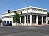 | January 9, 1978 (#78001069) | 100 E. Main St. 42°43′27″N 114°31′06″W / 42.72414°N 114.51842°W / 42.72414; -114.51842 (Jerome National Bank) | Jerome | |
| 32 | Edgar Johnson House |  | September 8, 1983 (#83002340) | South of Jerome 42°40′50″N 114°30′27″W / 42.680556°N 114.5075°W / 42.680556; -114.5075 (Edgar Johnson House) | Jerome | |
| 33 | Clarence Keating House | 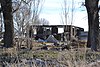 | September 8, 1983 (#83002341) | Northeast of Jerome 42°45′26″N 114°27′41″W / 42.757222°N 114.461389°W / 42.757222; -114.461389 (Clarence Keating House) | Jerome | |
| 34 | Thomas J. Kehrer House |  | September 8, 1983 (#83002342) | North of Jerome 42°48′59″N 114°31′42″W / 42.816389°N 114.528333°W / 42.816389; -114.528333 (Thomas J. Kehrer House) | Jerome | |
| 35 | Marion and Julia Kelley House |  | September 8, 1983 (#83002343) | 450 4th St., E. 42°35′31″N 114°07′56″W / 42.591944°N 114.132222°W / 42.591944; -114.132222 (Marion and Julia Kelley House) | Hazelton | |
| 36 | Ben Laughlin Water Tank House-Garage | Upload image | September 8, 1983 (#83002337) | East of Jerome 42°40′29″N 114°23′06″W / 42.674722°N 114.385°W / 42.674722; -114.385 (Ben Laughlin Water Tank House-Garage) | Jerome | |
| 37 | George Lawshe Well House | Upload image | September 8, 1983 (#83002336) | Southeast of Jerome 42°39′59″N 114°25′27″W / 42.666389°N 114.424167°W / 42.666389; -114.424167 (George Lawshe Well House) | Jerome | |
| 38 | J. O. Lee House | 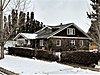 | September 8, 1983 (#83002335) | 5th Ave., E. 42°43′45″N 114°30′46″W / 42.729167°N 114.512778°W / 42.729167; -114.512778 (J. O. Lee House) | Jerome | |
| 39 | J. O. Lee Honey House |  | September 8, 1983 (#83002334) | 5th Ave., E. 42°43′45″N 114°30′47″W / 42.729167°N 114.513056°W / 42.729167; -114.513056 (J. O. Lee Honey House) | Jerome | |
| 40 | Joseph Mandl House | 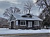 | September 8, 1983 (#83002333) | 800 N. Fillmore St. 42°43′52″N 114°30′28″W / 42.731111°N 114.507778°W / 42.731111; -114.507778 (Joseph Mandl House) | Jerome | |
| 41 | Milner Dam and the Twin Falls Main Canal |  | July 10, 1986 (#86001720) | Twin Falls Main Canal between Murtaugh and Milner Lakes 42°29′58″N 114°04′50″W / 42.499444°N 114.080556°W / 42.499444; -114.080556 (Milner Dam and the Twin Falls Main Canal) | Milner Butte | Extends into Twin Falls County |
| 42 | Minidoka Internment National Monument |  | July 10, 1979 (#79000791) | Hunt Rd. 42°40′42″N 114°15′00″W / 42.678333°N 114.25°W / 42.678333; -114.25 (Minidoka Internment National Monument) | Hunt | |
| 43 | J. W. and Rachel Newman House and Bunkhouse | Upload image | September 8, 1983 (#83002332) | East of Jerome 42°39′53″N 114°19′28″W / 42.664722°N 114.324444°W / 42.664722; -114.324444 (J. W. and Rachel Newman House and Bunkhouse) | Jerome | |
| 44 | North Side Canal Company Slaughter House | Upload image | September 8, 1983 (#83002331) | Northeast of Jerome 42°44′46″N 114°30′51″W / 42.746111°N 114.514167°W / 42.746111; -114.514167 (North Side Canal Company Slaughter House) | Jerome | |
| 45 | Jessie Osborne House | Upload image | September 8, 1983 (#83002329) | West of Jerome 42°43′33″N 114°36′28″W / 42.725833°N 114.607778°W / 42.725833; -114.607778 (Jessie Osborne House) | Jerome | |
| 46 | Greer and Jennie Quay House |  | September 8, 1983 (#83002330) | Northeast of Jerome 42°45′50″N 114°30′03″W / 42.763889°N 114.500833°W / 42.763889; -114.500833 (Greer and Jennie Quay House) | Jerome | |
| 47 | Julian T. Ricketts House |  | September 8, 1983 (#83002328) | Southeast of Jerome 42°40′51″N 114°25′15″W / 42.680833°N 114.420833°W / 42.680833; -114.420833 (Julian T. Ricketts House) | Jerome | |
| 48 | John F. Schmerschall House |  | September 8, 1983 (#83002327) | 248 E. Ave. A 42°43′27″N 114°30′53″W / 42.724167°N 114.514722°W / 42.724167; -114.514722 (John F. Schmerschall House) | Jerome | |
| 49 | L. Fay Shepard House | Upload image | September 8, 1983 (#83002300) | South of Hazelton 42°30′41″N 114°08′57″W / 42.511389°N 114.149167°W / 42.511389; -114.149167 (L. Fay Shepard House) | Hazelton | |
| 50 | Shoshone Falls Power Plant Caretaker's House | Upload image | September 8, 1983 (#83002301) | Southeast of Jerome 42°35′50″N 114°24′08″W / 42.597222°N 114.402222°W / 42.597222; -114.402222 (Shoshone Falls Power Plant Caretaker's House) | Jerome | |
| 51 | W. H. Silbaugh House | Upload image | September 8, 1983 (#83002302) | West of Jerome 42°43′26″N 114°35′31″W / 42.723889°N 114.591944°W / 42.723889; -114.591944 (W. H. Silbaugh House) | Jerome | |
| 52 | Edward S. Spencer House and Garage and the Fred Nelson Barn |  | September 8, 1983 (#83002303) | North of Jerome 42°49′27″N 114°30′10″W / 42.824167°N 114.502778°W / 42.824167; -114.502778 (Edward S. Spencer House and Garage and the Fred Nelson Barn) | Jerome | |
| 53 | Arnold Stevens House |  | September 8, 1983 (#83002304) | West of Jerome 42°43′32″N 114°35′12″W / 42.725556°N 114.586667°W / 42.725556; -114.586667 (Arnold Stevens House) | Jerome | |
| 54 | John Stickel House | Upload image | September 8, 1983 (#83002305) | West of Jerome 42°42′42″N 114°34′39″W / 42.711667°N 114.5775°W / 42.711667; -114.5775 (John Stickel House) | Jerome | |
| 55 | Sugarloaf School |  | September 8, 1983 (#83002306) | East of Jerome 42°41′26″N 114°21′54″W / 42.690556°N 114.365°W / 42.690556; -114.365 (Sugarloaf School) | Jerome | |
| 56 | Rice Thomason Barn |  | September 8, 1983 (#83002307) | East of Jerome 42°41′40″N 114°23′00″W / 42.694444°N 114.383333°W / 42.694444; -114.383333 (Rice Thomason Barn) | Jerome | |
| 57 | Don Tooley House |  | September 8, 1983 (#83002308) | Northeast of Jerome 42°46′35″N 114°28′30″W / 42.776389°N 114.475°W / 42.776389; -114.475 (Don Tooley House) | Jerome | |
| 58 | Jay Van Hook Potato Cellar | Upload image | September 8, 1983 (#83002309) | South of Jerome 42°41′50″N 114°31′05″W / 42.697222°N 114.518056°W / 42.697222; -114.518056 (Jay Van Hook Potato Cellar) | Jerome | |
| 59 | Jacob B. Van Wagener Barn |  | September 8, 1983 (#83002310) | Southeast of Jerome 42°40′53″N 114°26′38″W / 42.681389°N 114.443889°W / 42.681389; -114.443889 (Jacob B. Van Wagener Barn) | Jerome | |
| 60 | Jacob B. Van Wagener Caretaker's House | Upload image | September 8, 1983 (#83002311) | Southeast of Jerome 42°41′01″N 114°26′35″W / 42.683611°N 114.443056°W / 42.683611; -114.443056 (Jacob B. Van Wagener Caretaker's House) | Jerome | |
| 61 | William T. and Clara H. Veazie House | Upload image | September 8, 1983 (#83002312) | Southwest of Jerome 42°40′30″N 114°34′33″W / 42.675°N 114.575833°W / 42.675; -114.575833 (William T. and Clara H. Veazie House) | Jerome | |
| 62 | Charles C. Vineyard House | 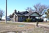 | September 8, 1983 (#83002313) | Southwest of Eden 42°35′29″N 114°19′36″W / 42.591389°N 114.326667°W / 42.591389; -114.326667 (Charles C. Vineyard House) | Eden | |
| 63 | Thomas Vipham House |  | September 8, 1983 (#83002314) | 313 E. Ave. D 42°43′12″N 114°30′47″W / 42.72°N 114.513056°W / 42.72; -114.513056 (Thomas Vipham House) | Jerome | |
| 64 | Archie Webster House |  | September 8, 1983 (#83002316) | West Ave. and W. Ave. B 42°43′19″N 114°31′50″W / 42.721944°N 114.530556°W / 42.721944; -114.530556 (Archie Webster House) | Jerome | |
| 65 | William Weigle House and Water Tank |  | September 8, 1983 (#83002315) | Northwest of Jerome 42°45′36″N 114°35′45″W / 42.76°N 114.595833°W / 42.76; -114.595833 (William Weigle House and Water Tank) | Jerome | |
| 66 | Wilson Butte Cave |  | November 21, 1974 (#74000741) | Address Restricted | Hunt |
See also
Wikimedia Commons has media related to National Register of Historic Places in Jerome County, Idaho.
References
- ^ The latitude and longitude information provided in this table was derived originally from the National Register Information System, which has been found to be fairly accurate for about 99% of listings. Some locations in this table may have been corrected to current GPS standards.
- ^ "National Register of Historic Places: Weekly List Actions". National Park Service. Retrieved March 29, 2009.
- ^ National Park Service, United States Department of the Interior, "National Register of Historic Places: Weekly List Actions", retrieved June 28, 2024.
- ^ Numbers represent an alphabetical ordering by significant words. Various colorings, defined here, differentiate National Historic Landmarks and historic districts from other NRHP buildings, structures, sites or objects.
- ^ "National Register Information System". National Register of Historic Places. National Park Service. April 24, 2008.
- ^ The eight-digit number below each date is the number assigned to each location in the National Register Information System database, which can be viewed by clicking the number.
- v
- t
- e
- Ada
- Adams
- Bannock
- Bear Lake
- Benewah
- Bingham
- Blaine
- Boise
- Bonner
- Bonneville
- Boundary
- Butte
- Camas
- Canyon
- Caribou
- Cassia
- Clark
- Clearwater
- Custer
- Elmore
- Franklin
- Fremont
- Gem
- Gooding
- Idaho
- Jefferson
- Jerome
- Kootenai
- Latah
- Lemhi
- Lewis
- Lincoln
- Madison
- Minidoka
- Nez Perce
- Oneida
- Owyhee
- Payette
- Power
- Shoshone
- Teton
- Twin Falls
- Valley
- Washington

| |
|---|---|
| Topics | |
| Lists by state |
|
| Lists by insular areas | |
| Lists by associated state | |
| Other areas | |
| Related | |
| |


Municipalities and communities of Jerome County, Idaho, United States | ||
|---|---|---|
County seat: Jerome | ||
| Cities |  | |
| Unincorporated communities |
‡This populated place also has portions in an adjacent county or counties | |
| ||


