National Register of Historic Places listings in Shoshone County, Idaho
This is a list of the National Register of Historic Places listings in Shoshone County, Idaho.
This is intended to be a complete list of the properties and districts on the National Register of Historic Places in Shoshone County, Idaho, United States. Latitude and longitude coordinates are provided for many National Register properties and districts; these locations may be seen together in a map.[1]
There are 24 properties and districts listed on the National Register in the county. More may be added; properties and districts nationwide are added to the Register weekly.[2]
This National Park Service list is complete through NPS recent listings posted June 7, 2024.[3]
Map all coordinates using OpenStreetMap
Download coordinates as:
- KML
- GPX (all coordinates)
- GPX (primary coordinates)
- GPX (secondary coordinates)
Current listings
| [4] | Name on the Register[5] | Image | Date listed[6] | Location | City or town | Description |
|---|---|---|---|---|---|---|
| 1 | Avery Depot |  | September 20, 1984 (#84001142) | St. Joe River Rd. 47°15′03″N 115°48′26″W / 47.250797°N 115.807348°W / 47.250797; -115.807348 (Avery Depot) | Avery | |
| 2 | Avery Ranger Station | 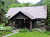 | June 27, 1974 (#74000748) | Near the St. Joe National Forest 47°15′04″N 115°48′20″W / 47.251063°N 115.805636°W / 47.251063; -115.805636 (Avery Ranger Station) | Avery | |
| 3 | Bullion Tunnel | Upload image | September 20, 1984 (#84001160) | East of Avery 47°24′04″N 115°42′04″W / 47.401111°N 115.701111°W / 47.401111; -115.701111 (Bullion Tunnel) | Avery | |
| 4 | Cedar Snags |  | September 20, 1984 (#84001174) | North of Avery 47°22′30″N 115°45′42″W / 47.374888°N 115.761651°W / 47.374888; -115.761651 (Cedar Snags) | Avery | |
| 5 | Chicago, Milwaukee, St. Paul and Pacific Railroad Company Historic District |  | October 26, 2000 (#00001269) | Idaho Panhandle National Forest 47°21′37″N 115°38′43″W / 47.360167°N 115.645222°W / 47.360167; -115.645222 (Chicago, Milwaukee, St. Paul and Pacific Railroad Company Historic District) | Avery | Extends into Mineral County, Montana |
| 6 | John C. Feehan House | Upload image | August 27, 1980 (#80001334) | Main St. 47°37′36″N 115°51′05″W / 47.626667°N 115.851389°W / 47.626667; -115.851389 (John C. Feehan House) | Murray | |
| 7 | Grand Forks | Upload image | September 20, 1984 (#84001175) | East of Avery 47°21′12″N 115°40′25″W / 47.353227°N 115.673701°W / 47.353227; -115.673701 (Grand Forks) | Avery | |
| 8 | Halm Creek, Bean Creek Fire | Upload image | September 20, 1984 (#84001177) | South of Red Ives 47°00′27″N 115°21′13″W / 47.0075°N 115.353611°W / 47.0075; -115.353611 (Halm Creek, Bean Creek Fire) | Red Ives | |
| 9 | Kellogg Boy Scout Cabin | 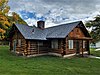 | September 22, 2021 (#100007006) | 2 South Hill St. 47°32′13″N 116°07′40″W / 47.5369°N 116.1277°W / 47.5369; -116.1277 (Kellogg Boy Scout Cabin) | Kellogg | |
| 10 | Magee Ranger Station |  | February 18, 1981 (#81000208) | West of Pritchard 47°50′39″N 116°15′09″W / 47.844054°N 116.252468°W / 47.844054; -116.252468 (Magee Ranger Station) | Pritchard | |
| 11 | Mallard Peak Lookout | Upload image | April 12, 1984 (#84001178) | Southeast of Avery 46°56′17″N 115°31′30″W / 46.938093°N 115.524903°W / 46.938093; -115.524903 (Mallard Peak Lookout) | Avery | |
| 12 | Miner's Hat | 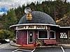 | September 23, 2021 (#100007007) | 300 East Cameron Ave. 47°32′10″N 116°06′48″W / 47.5362°N 116.1134°W / 47.5362; -116.1134 (Miner's Hat) | Kellogg | |
| 13 | Murray Courthouse |  | November 14, 1978 (#78001098) | Main St. 47°37′36″N 115°51′15″W / 47.626578°N 115.854172°W / 47.626578; -115.854172 (Murray Courthouse) | Murray | Collapsed due to snow load in 1997; subsequently rebuilt in replica.[7] |
| 14 | Murray Masonic Hall |  | May 19, 1987 (#87000774) | Main St. between 2nd and 3rd 47°37′37″N 115°51′29″W / 47.626832°N 115.858062°W / 47.626832; -115.858062 (Murray Masonic Hall) | Murray | |
| 15 | Northern Pacific Railway Depot |  | April 2, 1976 (#76000681) | 219 6th St. 47°28′24″N 115°55′25″W / 47.473247°N 115.923603°W / 47.473247; -115.923603 (Northern Pacific Railway Depot) | Wallace | Built in 1906, relocated in 1986 due to Interstate 90 construction.[8] |
| 16 | Pine Creek Baptist Church |  | November 17, 1982 (#82000361) | Main and S. 3rd Sts. 47°32′19″N 116°14′13″W / 47.53871°N 116.23684°W / 47.53871; -116.23684 (Pine Creek Baptist Church) | Pinehurst | Designed by Tourtellotte & Hummel, built in 1932 |
| 17 | Edward Pulaski Tunnel and Placer Creek Escape Route |  | September 20, 1984 (#84001179) | Southwest of Wallace 47°26′58″N 115°57′24″W / 47.449444°N 115.956667°W / 47.449444; -115.956667 (Edward Pulaski Tunnel and Placer Creek Escape Route) | Wallace | |
| 18 | Red Ives Ranger Station |  | September 13, 1986 (#86002151) | Southeast of Avery on Forest Service Rd. 218 47°03′22″N 115°21′08″W / 47.056145°N 115.352316°W / 47.056145; -115.352316 (Red Ives Ranger Station) | Avery | |
| 19 | St. Andrew's Episcopal Church | 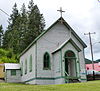 | April 1, 1999 (#99000419) | 104 Hunter St. 47°28′12″N 115°48′11″W / 47.470095°N 115.802944°W / 47.470095; -115.802944 (St. Andrew's Episcopal Church) | Mullan | |
| 20 | U.S. Post Office – Kellogg Main |  | May 30, 1990 (#89002118) | 302 S. Division St. 47°32′04″N 116°07′18″W / 47.534526°N 116.121742°W / 47.534526; -116.121742 (U.S. Post Office – Kellogg Main) | Kellogg | |
| 21 | U.S. Post Office – Wallace Main |  | March 16, 1989 (#89000137) | 403 Cedar St. 47°28′21″N 115°55′36″W / 47.472617°N 115.926711°W / 47.472617; -115.926711 (U.S. Post Office – Wallace Main) | Wallace | |
| 22 | Wallace 1910 Fire Memorial | 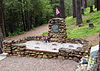 | September 20, 1984 (#84001180) | North of Wallace 47°29′16″N 115°54′56″W / 47.487704°N 115.915564°W / 47.487704; -115.915564 (Wallace 1910 Fire Memorial) | Wallace | |
| 23 | Wallace Carnegie Library |  | February 3, 1981 (#81000209) | 415 River St. 47°28′27″N 115°55′34″W / 47.474189°N 115.926149°W / 47.474189; -115.926149 (Wallace Carnegie Library) | Wallace | |
| 24 | Wallace Historic District |  | August 10, 1979 (#79000809) | Roughly bounded by Oak, Silver, C, Mullan, Canyon, Fir, and 1st Sts. 47°28′20″N 115°55′34″W / 47.4723°N 115.9262°W / 47.4723; -115.9262 (Wallace Historic District) | Wallace |
See also
Wikimedia Commons has media related to National Register of Historic Places in Shoshone County, Idaho.
References
- ^ The latitude and longitude information provided in this table was derived originally from the National Register Information System, which has been found to be fairly accurate for about 99% of listings. Some locations in this table may have been corrected to current GPS standards.
- ^ "National Register of Historic Places: Weekly List Actions". National Park Service. Retrieved March 29, 2009.
- ^ National Park Service, United States Department of the Interior, "National Register of Historic Places: Weekly List Actions", retrieved June 7, 2024.
- ^ Numbers represent an alphabetical ordering by significant words. Various colorings, defined here, differentiate National Historic Landmarks and historic districts from other NRHP buildings, structures, sites or objects.
- ^ "National Register Information System". National Register of Historic Places. National Park Service. April 24, 2008.
- ^ The eight-digit number below each date is the number assigned to each location in the National Register Information System database, which can be viewed by clicking the number.
- ^ Renk, Nancy Foster (October 29, 2012), Shoshone County and Its Courthouses (blog post), Preservation Idaho, archived from the original on June 2, 2015, retrieved April 12, 2015
- ^ Bond, David (May 11, 1986). "Wallace depot sees its last departure". Spokesman-Review. (Spokane, Washington). p. A1.
- v
- t
- e
- Ada
- Adams
- Bannock
- Bear Lake
- Benewah
- Bingham
- Blaine
- Boise
- Bonner
- Bonneville
- Boundary
- Butte
- Camas
- Canyon
- Caribou
- Cassia
- Clark
- Clearwater
- Custer
- Elmore
- Franklin
- Fremont
- Gem
- Gooding
- Idaho
- Jefferson
- Jerome
- Kootenai
- Latah
- Lemhi
- Lewis
- Lincoln
- Madison
- Minidoka
- Nez Perce
- Oneida
- Owyhee
- Payette
- Power
- Shoshone
- Teton
- Twin Falls
- Valley
- Washington

| |
|---|---|
| Topics | |
| Lists by state |
|
| Lists by insular areas | |
| Lists by associated state | |
| Other areas | |
| Related | |
| |


